IMAGES TAKEN NEAR TO
Bay View, CARMARTHEN, SA33 4FA
Introduction
This page details the photographs taken nearby to Bay View, SA33 4FA by members of the Geograph project.
The Geograph project started in 2005 with the aim of publishing, organising and preserving representative images for every square kilometre of Great Britain, Ireland and the Isle of Man.

There are currently over 7.5m images from over14,400 individuals and you can help contribute to the project by visiting https://www.geograph.org.uk
Image Map (Loading...)


Getting Data...Please wait
Leaflet Map data © OpenStreetMap
Images are licensed for reuse under creativecommons.org/licenses/by-sa/2.0
Notes
- Clicking on the map will re-center to the selected point.
- The higher the marker number, the further away the image location is from the centre of the postcode.
Image Listing (15 Images Found)
Images are licensed for reuse under creativecommons.org/licenses/by-sa/2.0
Image
Details
Distance
1
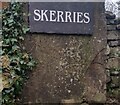
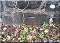
Ordnance Survey Cut Mark
This OS cut mark can be found on the redundant stone gatepost at Skerries, west side of Pendine Hill It marked a point 77.770m above mean sea level.
Image: © Adrian Dust
Taken: 16 Dec 2021
0.03 miles
2
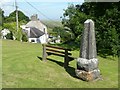
Obelisk on the green, Pendine
This is the middle part of Pendine, between the village at the top and the seaside resort at the bottom. From memory, the obelisk commemorates the Coronation of Edward VII.
Image: © Humphrey Bolton
Taken: 29 Jun 2008
0.11 miles
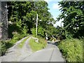
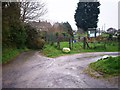
3
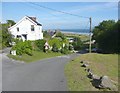
Lane, Pendine
This is a short cut if going through Pendine to Laugharne, but it is narrow and steep.
Image: © Humphrey Bolton
Taken: 29 Jun 2008
0.15 miles
4
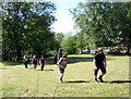
Pentywyn / Pendine
Cerddwyr yn mynd i gyfeiriad Eglwys Pentywyn.
Walkers heading in the direction of Pendine Church.
Image: © Alan Richards
Taken: 23 May 2010
0.16 miles
5
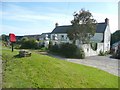
Great House Farm and a letter box, Pendine
The farmhouse was built in the 17C, but has been modernised since, eg sash windows. The entrance piers with their ball finials are late 17C or early 18C, according to the Pevsner guide.
Image: © Humphrey Bolton
Taken: 29 Jun 2008
0.17 miles
6
Ordnance Survey Cut Mark
This OS cut mark can be found on the wall west side of Pendine Hill. It marks a point 36.091m above mean sea level.
Image: © Adrian Dust
Taken: 16 Dec 2021
0.18 miles
8
Lane, Pendine / Pentywyn
This is a lane that comes down from Pendine village to the sea. There are several houses on each side of it, including The Rectory, set back from the lane with a driveway to it.
Image: © Humphrey Bolton
Taken: 29 Jun 2008
0.19 miles
9

Drain, Pendine Hill, Pendine
A king-size road gully.
Image: © Humphrey Bolton
Taken: 29 Jun 2008
0.20 miles
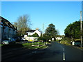
10
St Margaret's Church Pendine - lanes in front of church
Image: © welshbabe
Taken: 28 Mar 2014
0.22 miles