IMAGES TAKEN NEAR TO
Pentre Road, CARMARTHEN, SA33 4AA
Introduction
This page details the photographs taken nearby to Pentre Road, SA33 4AA by members of the Geograph project.
The Geograph project started in 2005 with the aim of publishing, organising and preserving representative images for every square kilometre of Great Britain, Ireland and the Isle of Man.

There are currently over 7.5m images from over14,400 individuals and you can help contribute to the project by visiting https://www.geograph.org.uk
Image Map
Images are licensed for reuse under creativecommons.org/licenses/by-sa/2.0
Notes
- Clicking on the map will re-center to the selected point.
- The higher the marker number, the further away the image location is from the centre of the postcode.
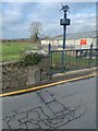
Image Listing (103 Images Found)
Images are licensed for reuse under creativecommons.org/licenses/by-sa/2.0
Image
Details
Distance
1
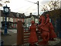
Wooden carved figures commemorating the 'Rebecca Riots', St Clears
Image: © David Gearing
Taken: 13 Oct 2015
0.01 miles
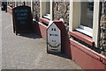
4
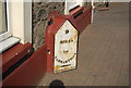
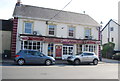
Milestone outside the Black Lion (2)
See alsoImage
Image: © N Chadwick
Taken: 25 Aug 2013
0.02 miles
5
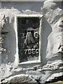
Ordnance Survey Flush Bracket (S7950)
This OS Flush Bracket can be found on the front of the Old Market Hall. It marks a point 7.870m above mean sea level.
Image: © Adrian Dust
Taken: 26 May 2014
0.02 miles
6

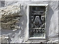
Bench Mark On -The Gate St Clears
Bench Mark LHS of doors.
Image: © John Jenkins
Taken: 18 Feb 2022
0.02 miles
7
Ordnance Survey Flush Bracket S7950
This can be found on the wall of the old Market Hall.
For more detail see : http://www.bench-marks.org.uk/bm268
Image: © Peter Wood
Taken: 23 May 2013
0.02 miles
9
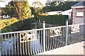
Wrought-iron art on the bridge at St Clears
These panels have a hunting theme, wild boar, greyhound, and hare and deer (?). They were later painted blue.
Image: © Humphrey Bolton
Taken: Unknown
0.03 miles
10
Old Boundary Stone in St Clears/Sancler
Parish Boundary Marker by the B4299 (was A40), in parish of St Clears (Carmarthenshire District), Pentre Road, St Clears, centre of town, next to bridge against wall.
To be surveyed
Milestone Society National ID: CAM_SCLLAB01pb.
Image: © Paul Hackett
Taken: 13 Feb 2020
0.03 miles