IMAGES TAKEN NEAR TO
Dryslwyn, CARMARTHEN, SA32 8SF
Introduction
This page details the photographs taken nearby to SA32 8SF by members of the Geograph project.
The Geograph project started in 2005 with the aim of publishing, organising and preserving representative images for every square kilometre of Great Britain, Ireland and the Isle of Man.

There are currently over 7.5m images from over14,400 individuals and you can help contribute to the project by visiting https://www.geograph.org.uk
Image Map
Images are licensed for reuse under creativecommons.org/licenses/by-sa/2.0
Notes
- Clicking on the map will re-center to the selected point.
- The higher the marker number, the further away the image location is from the centre of the postcode.
Image Listing (6 Images Found)
Images are licensed for reuse under creativecommons.org/licenses/by-sa/2.0
Image
Details
Distance
1

Black Lion
No evidence that this was once a pub, but the name sounds like it. Otherwise, just a typical stone farmhouse in the southern part of the square.
Image: © Graham Horn
Taken: 20 Oct 2008
0.02 miles
2
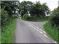
Cyffordd o heolydd bach / A junction of minor roads
Cyffordd o heolydd bach ger Ffarm Ty-coch.
A junction of minor roads near Ty-coch Farm (trans. red house).
Image: © Alan Richards
Taken: 23 Aug 2020
0.02 miles
3
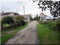
Heol fach ger ffarm / Minor road near a farm
Heol fach yn mynd heibio i Ffarm Ty-coch.
A minor road passing Ty-coch Farm (trans. red house).
Image: © Alan Richards
Taken: 23 Aug 2020
0.06 miles
4
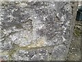
Ordnance Survey Cut Mark
This OS cut mark can be found on a barn at Tycoch. It marks a point 113.087m above mean sea level.
Image: © Adrian Dust
Taken: 4 Feb 2023
0.06 miles
5

Brynbach
Farm in the north of the square.
Image: © Graham Horn
Taken: 20 Oct 2008
0.10 miles
