IMAGES TAKEN NEAR TO
Maesawelon, CARMARTHEN, SA32 8RY
Introduction
This page details the photographs taken nearby to Maesawelon, SA32 8RY by members of the Geograph project.
The Geograph project started in 2005 with the aim of publishing, organising and preserving representative images for every square kilometre of Great Britain, Ireland and the Isle of Man.

There are currently over 7.5m images from over14,400 individuals and you can help contribute to the project by visiting https://www.geograph.org.uk
Image Map
Images are licensed for reuse under creativecommons.org/licenses/by-sa/2.0
Notes
- Clicking on the map will re-center to the selected point.
- The higher the marker number, the further away the image location is from the centre of the postcode.
Image Listing (5 Images Found)
Images are licensed for reuse under creativecommons.org/licenses/by-sa/2.0
Image
Details
Distance
2

New bungalows at Court Henry
Each one has a different colour for their end wall. They looked more striking in real life.
Image: © Graham Horn
Taken: 20 Oct 2008
0.12 miles
3
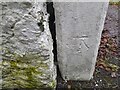
Ordnance Survey Cut Mark
This OS cut mark can be found on the gatepost of Pant-y-ffynnon. It marks a point 64.002m above mean sea level.
Image: © Adrian Dust
Taken: 4 Feb 2023
0.17 miles
4
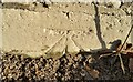
Ordnance Survey Cut Mark
This OS cut mark can be found on the NE parapet of Pont Cwrt Henry. It marks a point 32.484m above mean sea level.
Image: © Adrian Dust
Taken: 19 Nov 2016
0.19 miles