IMAGES TAKEN NEAR TO
Llangathen, CARMARTHEN, SA32 8QF
Introduction
This page details the photographs taken nearby to SA32 8QF by members of the Geograph project.
The Geograph project started in 2005 with the aim of publishing, organising and preserving representative images for every square kilometre of Great Britain, Ireland and the Isle of Man.

There are currently over 7.5m images from over14,400 individuals and you can help contribute to the project by visiting https://www.geograph.org.uk
Image Map
Images are licensed for reuse under creativecommons.org/licenses/by-sa/2.0
Notes
- Clicking on the map will re-center to the selected point.
- The higher the marker number, the further away the image location is from the centre of the postcode.
Image Listing (3 Images Found)
Images are licensed for reuse under creativecommons.org/licenses/by-sa/2.0
Image
Details
Distance
1
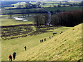
Ger / Near Cilsan Bridge
Cerddwyr yn mynd i lawr y waered i ymuno a'r heol. Yn y pellter gwelir Pont Cilsan sy'n rhychwantu Afon Tywi.
Walkers descending the hill towards the road. Visible in the distance is Cilsan Bridge which spans the Tywi River.
Image: © Alan Richards
Taken: 21 Feb 2010
0.15 miles
2
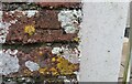
Ordnance Survey Cut Mark
This OS cut mark can be found on the outbuilding of School House. It marks a point 108.963m above mean sea level.
Image: © Adrian Dust
Taken: 15 Mar 2021
0.17 miles