IMAGES TAKEN NEAR TO
Porthyrhyd, CARMARTHEN, SA32 8PN
Introduction
This page details the photographs taken nearby to SA32 8PN by members of the Geograph project.
The Geograph project started in 2005 with the aim of publishing, organising and preserving representative images for every square kilometre of Great Britain, Ireland and the Isle of Man.

There are currently over 7.5m images from over14,400 individuals and you can help contribute to the project by visiting https://www.geograph.org.uk
Image Map
Images are licensed for reuse under creativecommons.org/licenses/by-sa/2.0
Notes
- Clicking on the map will re-center to the selected point.
- The higher the marker number, the further away the image location is from the centre of the postcode.
Image Listing (8 Images Found)
Images are licensed for reuse under creativecommons.org/licenses/by-sa/2.0
Image
Details
Distance
2
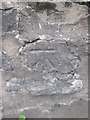
Ordnance Survey Cut Mark
This OS cut mark can be found on the east parapet of Pont Lan-Lucis. It marks a point 63.156m above mean sea level. http://www.geograph.org.uk/photo/4591757
Image: © Adrian Dust
Taken: 30 Jul 2015
0.14 miles
3
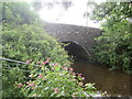
Pont Lan-Lucis
There is an Ordnance Survey cut mark on the east parapet. http://www.geograph.org.uk/photo/4591755
Image: © Adrian Dust
Taken: 30 Jul 2015
0.14 miles
4
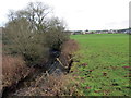
Llwybr Felin Fach / Felin Fach Path
Llwybr cyhoeddus yn mynd i gyfeiriad Felin Fach. Sylwer ar yr erydiad ar lan yr afon.
A public footpath heading in the direction of Felin Fach. Note the erosion of the river bank.
Image: © Alan Richards
Taken: 12 Jan 2018
0.16 miles
5
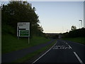
Road bridge near Porthyrhyd
Road bridge carrying the A48 dual carriageway over the B4310. The road junction is located beyond the bridge.
Image: © Martyn Harries
Taken: 14 Aug 2011
0.18 miles
6
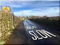
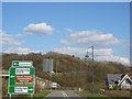
Bend in the B4310
Warning signs of bends in the road where the B4310 crosses the Pont Lan-Lucis.
Image: © Alan Hughes
Taken: 23 Jan 2019
0.19 miles

8
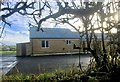
Community facilities
Sports facility at Porthyrhyd Football Club.
Image: © Alan Hughes
Taken: 23 Jan 2019
0.22 miles