IMAGES TAKEN NEAR TO
Llanddarog, CARMARTHEN, SA32 8NT
Introduction
This page details the photographs taken nearby to SA32 8NT by members of the Geograph project.
The Geograph project started in 2005 with the aim of publishing, organising and preserving representative images for every square kilometre of Great Britain, Ireland and the Isle of Man.

There are currently over 7.5m images from over14,400 individuals and you can help contribute to the project by visiting https://www.geograph.org.uk
Image Map
Images are licensed for reuse under creativecommons.org/licenses/by-sa/2.0
Notes
- Clicking on the map will re-center to the selected point.
- The higher the marker number, the further away the image location is from the centre of the postcode.
Image Listing (27 Images Found)
Images are licensed for reuse under creativecommons.org/licenses/by-sa/2.0
Image
Details
Distance
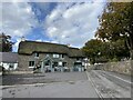
1
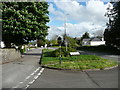
Junction of old and new roads, Llanddarog
The B4130 bypasses the narrow road past the church and inn.
Image: © Humphrey Bolton
Taken: 25 Apr 2019
0.02 miles
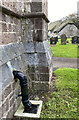
2
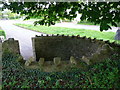
Fold in the churchyard wall, Llanddarog
This, with the churchyard wall and lychgate, is a scheduled ancient monument.
Image: © Humphrey Bolton
Taken: 25 Apr 2019
0.02 miles
3
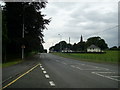
B4310 through Llanddarog
View of the B4310 through Llanddarog from the lay-by near Llanddarog school.
Image: © Martyn Harries
Taken: 27 Jul 2013
0.03 miles
4
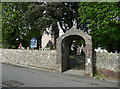
Lychgate to St Twrog's Church. Llanddarog
Image: © Humphrey Bolton
Taken: 25 Apr 2019
0.03 miles

6
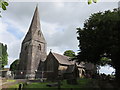
St Twrog?s Church, Llanddarog
The Church is dedicated to St Twrog, a Celtic saint who was apparently more active in north Wales. The earliest register dates from 1736. It is believed to have been built in 1854 on the site of a previous wooden building to a design by R K Pensan (1816-1886).
The spire, topped by a weathercock, is a local landmark as it can be seen for miles, at 150 feet tall.
Image: © Richard Rogerson
Taken: 12 Aug 2014
0.03 miles
8
Location of OS Cut Mark - Llanddarog, St Twrog's Church
Image: © thejackrustles
Taken: 7 Oct 2022
0.04 miles
9
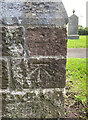
OS Cut Mark - Llanddarog, St Twrog's Church
https://www.bench-marks.org.uk/bm52252
Image: © thejackrustles
Taken: 7 Oct 2022
0.04 miles
10
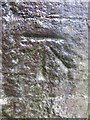
Ordnance Survey Cut Mark
This OS cut mark can be found on the tower of the church of St Twrog. It marks a point 117.07m above mean sea level.
Image: © Adrian Dust
Taken: 27 Oct 2013
0.04 miles