IMAGES TAKEN NEAR TO
Croesyceiliog, CARMARTHEN, SA32 8DS
Introduction
This page details the photographs taken nearby to SA32 8DS by members of the Geograph project.
The Geograph project started in 2005 with the aim of publishing, organising and preserving representative images for every square kilometre of Great Britain, Ireland and the Isle of Man.

There are currently over 7.5m images from over14,400 individuals and you can help contribute to the project by visiting https://www.geograph.org.uk
Image Map (Loading...)


Getting Data...Please wait
Leaflet Map data © OpenStreetMap
Images are licensed for reuse under creativecommons.org/licenses/by-sa/2.0
Notes
- Clicking on the map will re-center to the selected point.
- The higher the marker number, the further away the image location is from the centre of the postcode.
Image Listing (8 Images Found)
Images are licensed for reuse under creativecommons.org/licenses/by-sa/2.0
Image
Details
Distance
1
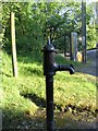
Handpump in Croesyceiliog
At the roadside just on the north side of the bridge in Croesyceiliog is this water pump. It has a fresh coat of black paint, but I didn't try to see if it actually works.
Also in the picture are the finger post for a public footpath and a phone box also marked on the map.
Image: © Nigel Davies
Taken: 31 May 2006
0.04 miles
2
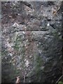
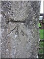
Ordnance Survey Cut Mark
This OS cut mark can be found on a gatepost to the east of the road. It marks a point 29.095m above mean sea level.
Image: © Adrian Dust
Taken: 8 Mar 2014
0.08 miles
3
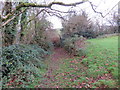
Llwybr Croesyceiliog / Croesyceiliog Path
Llwybr cyhoeddus yn arwain at bentre Croesyceiliog.
A public footpath heading towards the village of Croesyceiliog (cock's crossroads).
Image: © Alan Richards
Taken: 4 Dec 2019
0.09 miles
4
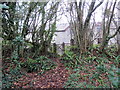
Llwybr Croesyceiliog / Croesyceiliog Path
Llwybr cyhoeddus yn cyrraedd yr heol ym mhentre Croesyceiliog.
A public footpath joining the road in the village of Croesyceiliog (trans. cock's crossroads).
Image: © Alan Richards
Taken: 4 Dec 2019
0.16 miles
5
Ordnance Survey Cut Mark
This OS cut mark can be found on the wall to the SE of the road junction. It marks a point 52.564m above mean sea level.
Image: © Adrian Dust
Taken: 8 Mar 2014
0.17 miles
6
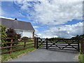
Glasdir, Croesyceiliog
Bungalow in Croesyceiliog.
Image: © Alan Hughes
Taken: 3 Aug 2020
0.18 miles
7
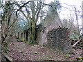
Adfeilion Ty'r Cwm / Ty'r Cwm ruins
Llwybr cyhoeddus yn mynd heibio i adfeilion Ty'r Cwm.
A public footpath passing the ruins of Ty'r Cwm (trans. valley house).
Image: © Alan Richards
Taken: 4 Dec 2019
0.20 miles
8
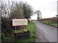
Pentre Croesyceiliog / Croesyceiliog village
Cyrraedd pentre Croesyceiliog.
Entering the village of Croesyceiliog (trans. cock's crossroads).
Image: © Alan Richards
Taken: 4 Dec 2019
0.22 miles