IMAGES TAKEN NEAR TO
Croesyceiliog, CARMARTHEN, SA32 8DN
Introduction
This page details the photographs taken nearby to SA32 8DN by members of the Geograph project.
The Geograph project started in 2005 with the aim of publishing, organising and preserving representative images for every square kilometre of Great Britain, Ireland and the Isle of Man.

There are currently over 7.5m images from over14,400 individuals and you can help contribute to the project by visiting https://www.geograph.org.uk
Image Map
Images are licensed for reuse under creativecommons.org/licenses/by-sa/2.0
Notes
- Clicking on the map will re-center to the selected point.
- The higher the marker number, the further away the image location is from the centre of the postcode.
Image Listing (9 Images Found)
Images are licensed for reuse under creativecommons.org/licenses/by-sa/2.0
Image
Details
Distance
1
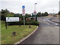
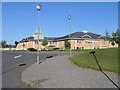
Ysgol Bro Myrddin
Ysgol Bro Myrddin, ysgol gyfun sy'n dysgu ei disgyblion yn bennaf drwy gyfrwng y Gymraeg.
Ysgol Bro Myrddin, a comprehensive school that teaches its pupils mostly through the medium of Welsh.
Image: © Alan Richards
Taken: 7 Sep 2020
0.01 miles
2
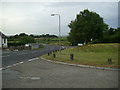
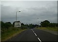
Bend in the road
View along the bend in the road heading for the A484 near Carmarthen from Croesyceiliog, from the entrance to Bro Myrddin school.
Image: © Martyn Harries
Taken: 27 Jul 2013
0.01 miles
3
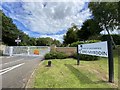
Ysgol Bro Myrddin
Entrance to Ysgol Bro Myrddin.
Image: © Alan Hughes
Taken: 3 Aug 2020
0.02 miles
4
Looking towards Bro Myrddin school
The edge of the square passes across the frontage of the school.
Image: © David Medcalf
Taken: 2 Oct 2007
0.07 miles
5

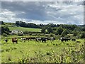
Heol ger ysgol / A road near a school
Heol yn agosau at ysgol.
A road approaching a school.
Image: © Alan Richards
Taken: 7 Sep 2020
0.09 miles
6
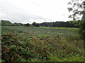
Marshland along Nant Pibwr
The course of the stream is the light green area
Image: © Eirian Evans
Taken: 22 Sep 2022
0.11 miles
7
The new Bro Myrddin school, Carmarthen
The old Bro Myrddin school in town was deemed unfit for children - and is now full of civil servants. The children have a newly built school outside town.
Image: © Nigel Davies
Taken: 31 May 2006
0.14 miles
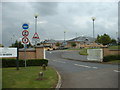
9
Roundabout sign near Pibwrlwyd
The roundabout sign is within the square and indicates the end of the minor road from Croesyceiliog, before joining the A484 roundabout near Pibwrlwyd.
Image: © Martyn Harries
Taken: 27 Jul 2013
0.20 miles