IMAGES TAKEN NEAR TO
Idole, CARMARTHEN, SA32 8DG
Introduction
This page details the photographs taken nearby to SA32 8DG by members of the Geograph project.
The Geograph project started in 2005 with the aim of publishing, organising and preserving representative images for every square kilometre of Great Britain, Ireland and the Isle of Man.

There are currently over 7.5m images from over14,400 individuals and you can help contribute to the project by visiting https://www.geograph.org.uk
Image Map
Images are licensed for reuse under creativecommons.org/licenses/by-sa/2.0
Notes
- Clicking on the map will re-center to the selected point.
- The higher the marker number, the further away the image location is from the centre of the postcode.
Image Listing (7 Images Found)
Images are licensed for reuse under creativecommons.org/licenses/by-sa/2.0
Image
Details
Distance
1
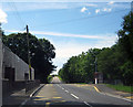
Village school at Idole
The school at Idole fronts onto the main A484 road, on the south western side of the village.
Image: © Peter Kazmierczak
Taken: 6 Aug 2013
0.02 miles
2
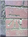
Ordnance Survey Cut Mark
This OS cut mark can be found on the brick post at the corner of the school wall. It marks a point 99.137m above mean sea level.
Image: © Adrian Dust
Taken: 8 Mar 2014
0.02 miles
3
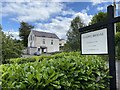
Chapel Bridal
Formerly Seion Chapel, Chapel Bridal is now a family run bridal boutique.
Image: © Alan Hughes
Taken: 3 Aug 2020
0.04 miles
4
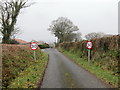
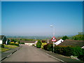
Cyrraedd Idole / Arriving at Idole
Heol fach yn cyrraedd pentre Idole.
A minor road entering the village of Idole.
Image: © Alan Richards
Taken: 7 Dec 2019
0.15 miles
6
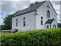
Seion, Idole
Former Baptist chapel at Idole, now converted into a bridal shop
Image: © Eirian Evans
Taken: 24 May 2022
0.21 miles
7
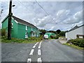
Green house
A green house in the village of Pentrepoeth.
Image: © Alan Hughes
Taken: 3 Aug 2020
0.24 miles