IMAGES TAKEN NEAR TO
Idole, CARMARTHEN, SA32 8DE
Introduction
This page details the photographs taken nearby to SA32 8DE by members of the Geograph project.
The Geograph project started in 2005 with the aim of publishing, organising and preserving representative images for every square kilometre of Great Britain, Ireland and the Isle of Man.

There are currently over 7.5m images from over14,400 individuals and you can help contribute to the project by visiting https://www.geograph.org.uk
Image Map
Images are licensed for reuse under creativecommons.org/licenses/by-sa/2.0
Notes
- Clicking on the map will re-center to the selected point.
- The higher the marker number, the further away the image location is from the centre of the postcode.
Image Listing (5 Images Found)
Images are licensed for reuse under creativecommons.org/licenses/by-sa/2.0
Image
Details
Distance
2
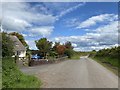
Llwybr ger Lan House / Path near Lan House
Llwybr cyhoeddus yn cyrraedd yr heol ger Lan House.
A public footpath joins the road near Lan House (trans. hill).
Image: © Alan Richards
Taken: 7 Dec 2019
0.10 miles
3
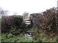
Llwybr Fforest Bowen / Fforest Bowen Path
Llwybr cyhoeddus yn mynd i gyfeiriad heol fach a Ffarm Fforest Bowen.
A public footpath heading in the direction of a minor road and Fforest Bowen Farm (trans. Bowen's forest).
Image: © Alan Richards
Taken: 7 Dec 2019
0.17 miles
4

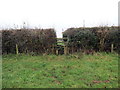
Field View at Lan Triangulation Pillar
Looking eastward.
Image: © Peter Wood
Taken: 23 Apr 2015
0.19 miles
5

Triangulation Pillar (S2394)
Lan 3rd Order Triangulation Pillar carries Flush Bracket S2394 which marks a point 140.111m above mean sea level.
Image: © Adrian Dust
Taken: 18 Oct 2007
0.20 miles