IMAGES TAKEN NEAR TO
Cwmffrwd, CARMARTHEN, SA32 8DB
Introduction
This page details the photographs taken nearby to SA32 8DB by members of the Geograph project.
The Geograph project started in 2005 with the aim of publishing, organising and preserving representative images for every square kilometre of Great Britain, Ireland and the Isle of Man.

There are currently over 7.5m images from over14,400 individuals and you can help contribute to the project by visiting https://www.geograph.org.uk
Image Map
Images are licensed for reuse under creativecommons.org/licenses/by-sa/2.0
Notes
- Clicking on the map will re-center to the selected point.
- The higher the marker number, the further away the image location is from the centre of the postcode.
Image Listing (7 Images Found)
Images are licensed for reuse under creativecommons.org/licenses/by-sa/2.0
Image
Details
Distance
1
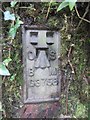
Ordnance Survey Flush Bracket (G3758)
This OS Flush Bracket can be found on the rock face to the east of the road. It marks a point 89.11m above mean sea level.
Image: © Adrian Dust
Taken: 8 Mar 2014
0.03 miles
2
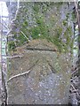
Ordnance Survey Cut Mark
This OS cut mark can be found on a gatepost to the west of the road. It marks a point 87.241m above mean sea level.
Image: © Adrian Dust
Taken: 8 Mar 2014
0.09 miles
3
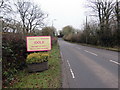
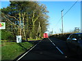
Pentre Idole / Idole Village
Yr A484 yn cyrraedd pentre Idole.
The A484 enters the village of Idole.
Image: © Alan Richards
Taken: 7 Dec 2019
0.10 miles
4
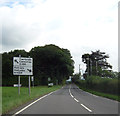
Road junction south of Cwmffrwd
Approaching the junction of the A484 with the B4309, south of Cwmffrwd.
Image: © Peter Kazmierczak
Taken: 8 Aug 2013
0.19 miles
5
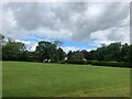
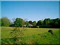
Perfectly mown grass at a Garden Machinery Dealers in Cwmffrwd
Image: © Eirian Evans
Taken: 24 May 2022
0.19 miles