IMAGES TAKEN NEAR TO
Porthyrhyd, CARMARTHEN, SA32 8BN
Introduction
This page details the photographs taken nearby to SA32 8BN by members of the Geograph project.
The Geograph project started in 2005 with the aim of publishing, organising and preserving representative images for every square kilometre of Great Britain, Ireland and the Isle of Man.

There are currently over 7.5m images from over14,400 individuals and you can help contribute to the project by visiting https://www.geograph.org.uk
Image Map (Loading...)


Getting Data...Please wait
Leaflet Map data © OpenStreetMap
Images are licensed for reuse under creativecommons.org/licenses/by-sa/2.0
Notes
- Clicking on the map will re-center to the selected point.
- The higher the marker number, the further away the image location is from the centre of the postcode.
Image Listing (16 Images Found)
Images are licensed for reuse under creativecommons.org/licenses/by-sa/2.0
Image
Details
Distance
1
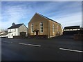
Bethlehem Baptist Chapel
Chapel in Porthyrhyd.
http://ukwells.org/wells/bethlehem-baptist-chapel-porthyrhyd
Image: © Alan Hughes
Taken: 23 Jan 2019
0.01 miles
2
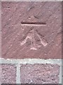
Ordnance Survey Cut Mark
This OS cut mark can be found on the front of No1 Carmarthen Road. It marks a point 64.264m above mean sea level.
Image: © Adrian Dust
Taken: 27 Oct 2013
0.02 miles
3
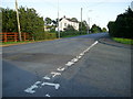
B4310 leaving Porthyrhyd
View of the B4310 heading south for Drefach from Porthyrhyd.
Image: © Martyn Harries
Taken: 14 Aug 2011
0.07 miles
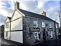
5
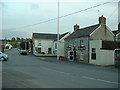
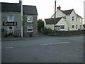
The Abadam Arms, Porthyrhyd
Image: © Alan Hughes
Taken: 23 Jan 2019
0.12 miles
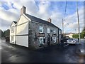
6
The Abadam Arms, Porthyrhyd
Formerly the Lord Nelson, damaged during the Rebecca riots of 1843 in which the nearby toll house and gate were destroyed.
http://www.nationalarchives.gov.uk/education/resources/rebecca-riots/
See also Image
Image: © Alan Hughes
Taken: 23 Jan 2019
0.13 miles
7
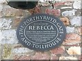
Rebecca riot plaque
Plaque commemorating the Rebecca riot at Porthyrhyd in 1843.
http://www.nationalarchives.gov.uk/education/resources/rebecca-riots/
See also Image
Image: © Alan Hughes
Taken: 23 Jan 2019
0.13 miles
8
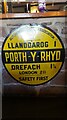
Old AA Sign on the B4310 in Porthyrhyd
Old AA Sign in front of the bar of the Abadam Arms PH on the southwest side of the B4310 in Porthyrhyd. Llanddarog community.
This is the Circular, village name on black band, no Motor Union symbol or name type, dating from 1923, showing distances Llanddarog 1 Drefach 1¾ London 211.
There were five series of AA signs, mostly dating from 1923 and made by Francis & Co / Franco in Deptford, London. The village name and distance to London were usually displayed.
Milestone Society National ID: CAM-PORTH
Image: © K Hackett
Taken: 25 Nov 2018
0.13 miles
9
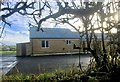
Community facilities
Sports facility at Porthyrhyd Football Club.
Image: © Alan Hughes
Taken: 23 Jan 2019
0.13 miles
10
Phone box, Porthyrhyd
The phone box standing close to the village pub in Porthyrhyd.
Image: © Martyn Harries
Taken: 14 Aug 2011
0.14 miles