IMAGES TAKEN NEAR TO
Llanddarog, CARMARTHEN, SA32 8BH
Introduction
This page details the photographs taken nearby to SA32 8BH by members of the Geograph project.
The Geograph project started in 2005 with the aim of publishing, organising and preserving representative images for every square kilometre of Great Britain, Ireland and the Isle of Man.

There are currently over 7.5m images from over14,400 individuals and you can help contribute to the project by visiting https://www.geograph.org.uk
Image Map (Loading...)


Getting Data...Please wait
Leaflet Map data © OpenStreetMap
Images are licensed for reuse under creativecommons.org/licenses/by-sa/2.0
Notes
- Clicking on the map will re-center to the selected point.
- The higher the marker number, the further away the image location is from the centre of the postcode.
Image Listing (5 Images Found)
Images are licensed for reuse under creativecommons.org/licenses/by-sa/2.0
Image
Details
Distance
1
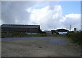
Pantyffynnon Hatchery
This is a hatchery where fertile hens' eggs are incubated until they hatch and the new chicks emerge. I am unsure if these are all sold as day-old chicks or if they are also reared here.
Image: © Marion Phillips
Taken: 24 Apr 2008
0.13 miles
2
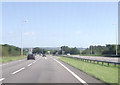
Road junction near Pantypwll
A48 eastbound
Image: © John Firth
Taken: 5 Sep 2012
0.17 miles
4
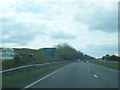
Penrhiw Hill
Penrhiw Farm lies beneath near to the A40 dual carriageway.
Image: © Deborah Tilley
Taken: 26 Jul 2008
0.19 miles
5
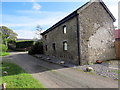
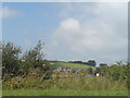
Ffarm Gelli-dywyll / Gelli-dywyll Farm
Heol fach yn mynd heibio i un o gyn dai mas Ffarm Gelli-dywyll. Mae'r adeilad wedi ei adnewyddu ac mae'n bosib taw hwn oedd y ty ffarm wreiddiol.
A minor road passing one of the former outhouses of Gelli-dywyll Farm (trans. dark grove). The building has been restored and it may possibly have been the original farmhouse.
Image: © Alan Richards
Taken: 26 Aug 2020
0.23 miles