IMAGES TAKEN NEAR TO
Llanfynydd, CARMARTHEN, SA32 7TN
Introduction
This page details the photographs taken nearby to SA32 7TN by members of the Geograph project.
The Geograph project started in 2005 with the aim of publishing, organising and preserving representative images for every square kilometre of Great Britain, Ireland and the Isle of Man.

There are currently over 7.5m images from over14,400 individuals and you can help contribute to the project by visiting https://www.geograph.org.uk
Image Map
Images are licensed for reuse under creativecommons.org/licenses/by-sa/2.0
Notes
- Clicking on the map will re-center to the selected point.
- The higher the marker number, the further away the image location is from the centre of the postcode.
Image Listing (5 Images Found)
Images are licensed for reuse under creativecommons.org/licenses/by-sa/2.0
Image
Details
Distance
1
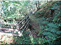
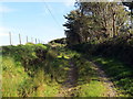
Llwybr ger Clawddowen / Path near Clawddowen
Llwybr cyhoeddus ger Ffarm Clawddowen.
A public footpath near Clawddowen Farm (trans. Owen's earthen wall).
Image: © Alan Richards
Taken: 18 Sep 2020
0.12 miles
2
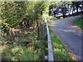
Llwybr yn gadael yr heol / Path exiting the road
Llwybr cyhoeddus ger Ffarm Clawddowen yn gadael yr heol.
A public footpath near Clawddowen Farm (trans. Owen's earthen wall) exiting the road.
Image: © Alan Richards
Taken: 18 Sep 2020
0.13 miles
3
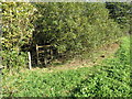
Sticil mewn perth / A stile in a hedge
Sticil mewn perth ond yn anffodus y mae'r llwybr yn y lleoliad hwn wedi ei hesgeuluso.
A stile in a hedge but unfortunately the path at this location is neglected.
Image: © Alan Richards
Taken: 18 Sep 2020
0.15 miles
4
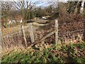
Sticil Clawddowen Stile, Llanfynydd
Sticil wael ger Ffarm Clawddowen, Llanfynydd / A poor stile near Clawddowen Farm, Llanfynydd
Image: © Alan Richards
Taken: 17 Feb 2013
0.15 miles
5
Llwybr yn nesau at heol / A path approaching a road
Llwybr cyhoeddus yn nesau at heol fach.
A public footpath approaching a minor road.
Image: © Alan Richards
Taken: 18 Sep 2020
0.22 miles