IMAGES TAKEN NEAR TO
Llanfynydd, CARMARTHEN, SA32 7TH
Introduction
This page details the photographs taken nearby to SA32 7TH by members of the Geograph project.
The Geograph project started in 2005 with the aim of publishing, organising and preserving representative images for every square kilometre of Great Britain, Ireland and the Isle of Man.

There are currently over 7.5m images from over14,400 individuals and you can help contribute to the project by visiting https://www.geograph.org.uk
Image Map (Loading...)


Getting Data...Please wait
Leaflet Map data © OpenStreetMap
Images are licensed for reuse under creativecommons.org/licenses/by-sa/2.0
Notes
- Clicking on the map will re-center to the selected point.
- The higher the marker number, the further away the image location is from the centre of the postcode.
Image Listing (5 Images Found)
Images are licensed for reuse under creativecommons.org/licenses/by-sa/2.0
Image
Details
Distance
1
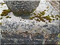
Ordnance Survey Rivet
This OS rivet can be found on the churn stand at the entrance to Blaen-Sannan. It marks a point 292.736m above mean sea level. https://www.geograph.org.uk/photo/7397142
Image: © Adrian Dust
Taken: 4 Feb 2023
0.11 miles
2
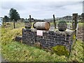
Churn Stand
There is an Ordnance Survey rivet on the top of the stand. https://www.geograph.org.uk/photo/7397138
Image: © Adrian Dust
Taken: 4 Feb 2023
0.11 miles
4
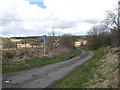
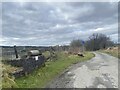
Lane
Looking west along the lane to Blaensannan.
Image: © Dara Jasumani
Taken: 21 Apr 2006
0.11 miles