IMAGES TAKEN NEAR TO
Abergorlech, CARMARTHEN, SA32 7SZ
Introduction
This page details the photographs taken nearby to SA32 7SZ by members of the Geograph project.
The Geograph project started in 2005 with the aim of publishing, organising and preserving representative images for every square kilometre of Great Britain, Ireland and the Isle of Man.

There are currently over 7.5m images from over14,400 individuals and you can help contribute to the project by visiting https://www.geograph.org.uk
Image Map (Loading...)


Getting Data...Please wait
Leaflet Map data © OpenStreetMap
Images are licensed for reuse under creativecommons.org/licenses/by-sa/2.0
Notes
- Clicking on the map will re-center to the selected point.
- The higher the marker number, the further away the image location is from the centre of the postcode.
Image Listing (5 Images Found)
Images are licensed for reuse under creativecommons.org/licenses/by-sa/2.0
Image
Details
Distance

2
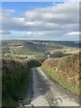
Country lane
Lane leading to Abergorlech.
Image: © Alan Hughes
Taken: 25 Feb 2023
0.12 miles
3
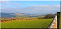
View East from above Trebwl
View towards Llansawel...
Image: © Oliver Strange
Taken: 7 Feb 2015
0.15 miles
4
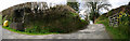
Lane Entrance
The lane to the property Trebwl.
Image: © Dara Jasumani
Taken: 21 Apr 2006
0.19 miles
5
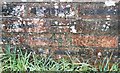
Ordnance Survey Cut Mark
This OS cut mark can be found on the milk stand of Trebwl Farm. It marks a point 204.588m above mean sea level.
Image: © Adrian Dust
Taken: 7 Jan 2017
0.21 miles