IMAGES TAKEN NEAR TO
Gwernogle, CARMARTHEN, SA32 7SG
Introduction
This page details the photographs taken nearby to SA32 7SG by members of the Geograph project.
The Geograph project started in 2005 with the aim of publishing, organising and preserving representative images for every square kilometre of Great Britain, Ireland and the Isle of Man.

There are currently over 7.5m images from over14,400 individuals and you can help contribute to the project by visiting https://www.geograph.org.uk
Image Map (Loading...)


Getting Data...Please wait
Leaflet Map data © OpenStreetMap
Images are licensed for reuse under creativecommons.org/licenses/by-sa/2.0
Notes
- Clicking on the map will re-center to the selected point.
- The higher the marker number, the further away the image location is from the centre of the postcode.
Image Listing (3 Images Found)
Images are licensed for reuse under creativecommons.org/licenses/by-sa/2.0
Image
Details
Distance
1
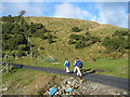
Ger / Near Rhos Wen
Cerddwyr yn dilyn heol farm ger Rhos Wen.
Walkers following a farm road near Rhos Wen (trans. fair moor).
Image: © Alan Richards
Taken: 28 Nov 2004
0.20 miles
2
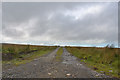
Track to Pant-troed-?s farm
A farm on the moors around the head of the Blotweth valley.
Image: © Nigel Brown
Taken: 17 Sep 2015
0.22 miles
3
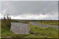
Track to Penrhiwdilfa farm
Also to an incinerator, according to the stone. Using stones for farm names seems to be recent common practice on the moors here.
Image: © Nigel Brown
Taken: 17 Sep 2015
0.24 miles