IMAGES TAKEN NEAR TO
Gwernogle, CARMARTHEN, SA32 7SE
Introduction
This page details the photographs taken nearby to SA32 7SE by members of the Geograph project.
The Geograph project started in 2005 with the aim of publishing, organising and preserving representative images for every square kilometre of Great Britain, Ireland and the Isle of Man.

There are currently over 7.5m images from over14,400 individuals and you can help contribute to the project by visiting https://www.geograph.org.uk
Image Map (Loading...)


Getting Data...Please wait
Leaflet Map data © OpenStreetMap
Images are licensed for reuse under creativecommons.org/licenses/by-sa/2.0
Notes
- Clicking on the map will re-center to the selected point.
- The higher the marker number, the further away the image location is from the centre of the postcode.
Image Listing (2 Images Found)
Images are licensed for reuse under creativecommons.org/licenses/by-sa/2.0
Image
Details
Distance
1
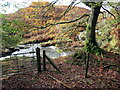
Rhyd Afon Blotweth / Afon Blotweth ford
Lleoliad lle mae llwybr ceffyl yn rhydio Afon Blotweth.
Location where a bridleway fords Afon Blotweth.
Image: © Alan Richards
Taken: 4 Nov 2022
0.19 miles
2
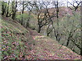
Llwybr i Afon Blotweth / Path to Afon Blotweth
Llwybr ceffyl yn mynd i lawr yr allt tuag at Afon Nenog.
A bridleway descends the hill towards Afon Blotweth.
Image: © Alan Richards
Taken: 4 Nov 2022
0.22 miles