IMAGES TAKEN NEAR TO
Nantgaredig, CARMARTHEN, SA32 7LX
Introduction
This page details the photographs taken nearby to SA32 7LX by members of the Geograph project.
The Geograph project started in 2005 with the aim of publishing, organising and preserving representative images for every square kilometre of Great Britain, Ireland and the Isle of Man.

There are currently over 7.5m images from over14,400 individuals and you can help contribute to the project by visiting https://www.geograph.org.uk
Image Map (Loading...)


Getting Data...Please wait
Leaflet Map data © OpenStreetMap
Images are licensed for reuse under creativecommons.org/licenses/by-sa/2.0
Notes
- Clicking on the map will re-center to the selected point.
- The higher the marker number, the further away the image location is from the centre of the postcode.
Image Listing (11 Images Found)
Images are licensed for reuse under creativecommons.org/licenses/by-sa/2.0
Image
Details
Distance
4
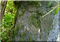
Ordnance Survey Cut Mark
This OS cut mark can be found on a gatepost buried in the hedge SE side of the road. It marks a point 47.316m above mean sea level.
Image: © Adrian Dust
Taken: 4 Jun 2021
0.22 miles
5
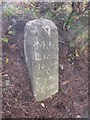
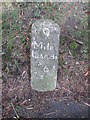
Old Milestone by the A40, near Pont-ar-gothi
Milestone by the A40, in parish of Llanegwad (Carmarthenshire District), West of Pont-ar-gothi, South side of road.
Inscription reads:-
9
Mile
LLandi
lo
6¾
Carma
rthen
Surveyed
Milestone Society National ID: CAM_LOCM09
Image: © Milestone Society
Taken: Unknown
0.22 miles
6
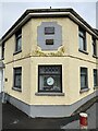
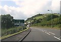
Former toll house, Nantgaredig
Toll house on the turnpike road at Nantgaredig - now the A40.
Image: © Alan Hughes
Taken: 15 Feb 2021
0.23 miles
7
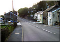
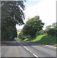
Nantgaredig
The A40 going through Nantgaredig.
Image: © Dara Jasumani
Taken: 2 Apr 2006
0.23 miles
8
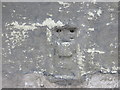
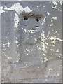
Ordnance Survey Flush Bracket G2981
This heavily over-painted bracket can be found on the wall of a building at the crossroads in Nantgaredig.
For more detail see : http://www.bench-marks.org.uk/bm11445
Image: © Peter Wood
Taken: 19 Apr 2015
0.24 miles
9
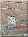
Ordnance Survey Flush Bracket (G2981)
This heavily painted over OS Flush Bracket (G2981) can be found on the north face of a house at the crossroads in Nantgaredig. It was once The Emporium. It was used during the Third Geodetic Levelling of England & Wales (1950-68) Llandovery - Carmarthen Levelling Line. It marks a point 30.0227m above mean sea level.
Image: © Adrian Dust
Taken: 2 Jun 2013
0.24 miles
10
OS Flush Bracket G2981 - Nantgaredig
https://www.bench-marks.org.uk/bm11445
Image: © thejackrustles
Taken: 9 Oct 2022
0.24 miles