IMAGES TAKEN NEAR TO
Station Road, CARMARTHEN, SA32 7LQ
Introduction
This page details the photographs taken nearby to Station Road, SA32 7LQ by members of the Geograph project.
The Geograph project started in 2005 with the aim of publishing, organising and preserving representative images for every square kilometre of Great Britain, Ireland and the Isle of Man.

There are currently over 7.5m images from over14,400 individuals and you can help contribute to the project by visiting https://www.geograph.org.uk
Image Map
Images are licensed for reuse under creativecommons.org/licenses/by-sa/2.0
Notes
- Clicking on the map will re-center to the selected point.
- The higher the marker number, the further away the image location is from the centre of the postcode.
Image Listing (5 Images Found)
Images are licensed for reuse under creativecommons.org/licenses/by-sa/2.0
Image
Details
Distance
1
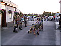
Woops!!!! Dropped my stick.
Entrance to Railway Hotel carpark, Nantgaredig. Vintage Bentley and Carreg-las dancers.
Image: © chris whitehouse
Taken: 8 Aug 2007
0.00 miles
2
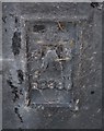
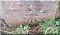
Ordnance Survey Flush Bracket (G2980)
This OS Flush Bracket can be found on the Ne angle of the Railway Hotel. It marks a point 15.940m above mean sea level.
Image: © Adrian Dust
Taken: 19 Nov 2016
0.02 miles
3
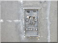
Ordnance Survey Flush Bracket G2980
This can be found on the wall of The Railway Hotel at Dyffry-Towy.
For more detail see : http://www.bench-marks.org.uk/bm14977
Image: © Peter Wood
Taken: 19 Apr 2015
0.03 miles
4
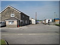
Nantgaredig railway station (site), Carmarthenshire
Opened in 1865 by the 'Llanelly' Railway on the line from Llandeilo to Carmarthen, this station closed in 1963.
View west towards Abergwili and Carmarthen. Complete with sign on the building. Now a private residence.
Image: © Nigel Thompson
Taken: 18 May 2014
0.03 miles
5
Ordnance Survey Cut Mark
This OS cut mark can be found on the wall of Llandilo-yr-ynys. It marks a point 14.111m above mean sea level.
Image: © Adrian Dust
Taken: 15 Mar 2021
0.24 miles