IMAGES TAKEN NEAR TO
Felingwm, CARMARTHEN, SA32 7LN
Introduction
This page details the photographs taken nearby to SA32 7LN by members of the Geograph project.
The Geograph project started in 2005 with the aim of publishing, organising and preserving representative images for every square kilometre of Great Britain, Ireland and the Isle of Man.

There are currently over 7.5m images from over14,400 individuals and you can help contribute to the project by visiting https://www.geograph.org.uk
Image Map
Images are licensed for reuse under creativecommons.org/licenses/by-sa/2.0
Notes
- Clicking on the map will re-center to the selected point.
- The higher the marker number, the further away the image location is from the centre of the postcode.
Image Listing (6 Images Found)
Images are licensed for reuse under creativecommons.org/licenses/by-sa/2.0
Image
Details
Distance
1
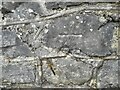
Ordnance Survey Cut Mark
This OS cut mark can be found on the wall east side of the road. It marks a point 54.528m above mean sea level.
Image: © Adrian Dust
Taken: 4 Feb 2023
0.06 miles
2
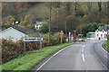
Felingwm Isaf
The B4310 as it enters Felingwm Isaf.
Image: © John Atherton
Taken: 6 Nov 2007
0.08 miles
3
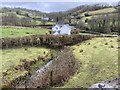
Cwm Cloidach
View towards Felingwmisaf.
Image: © Alan Hughes
Taken: 15 Feb 2021
0.09 miles
4
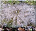
Ordnance Survey Rivet
This OS rivet can be found on the south parapet of the bridge over the River Cloida. It marks a point 44.044m above mean sea level.
Image: © Adrian Dust
Taken: 19 Nov 2016
0.12 miles
5
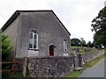
Capel Sitim Chapel
Sitim, Capel y Bedyddwyr yn Felingwm Isaf. Fe'i codwyd yn gyntaf yn 1817 ac fe'i hailadeiladwyd yn 1848. Mae'r addoldy presennol yn dyddio o 1874.
Sitim Baptist Chapel in Felingwm Isaf (trans. lower mill valley). The first meeting house was built in 1817 and it was rebuilt in 1848. The present chapel dates from 1874.
Image: © Alan Richards
Taken: 19 Jul 2014
0.14 miles
6
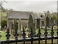
Country churchyard
Churchyard of Sittim Baptist Church, Felingwmisaf.
Image: © Alan Hughes
Taken: 15 Feb 2021
0.16 miles