IMAGES TAKEN NEAR TO
Abergorlech Road, CARMARTHEN, SA32 7JY
Introduction
This page details the photographs taken nearby to Abergorlech Road, SA32 7JY by members of the Geograph project.
The Geograph project started in 2005 with the aim of publishing, organising and preserving representative images for every square kilometre of Great Britain, Ireland and the Isle of Man.

There are currently over 7.5m images from over14,400 individuals and you can help contribute to the project by visiting https://www.geograph.org.uk
Image Map
Images are licensed for reuse under creativecommons.org/licenses/by-sa/2.0
Notes
- Clicking on the map will re-center to the selected point.
- The higher the marker number, the further away the image location is from the centre of the postcode.
Image Listing (5 Images Found)
Images are licensed for reuse under creativecommons.org/licenses/by-sa/2.0
Image
Details
Distance
1
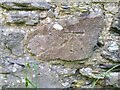
Ordnance Survey Cut Mark
This OS cut mark can be found on a barn at Rhiwiau. It marks a point 161.670m above mean sea level.
Image: © Adrian Dust
Taken: 4 Jun 2021
0.02 miles
2
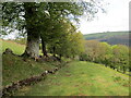
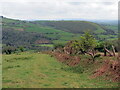
Llwybr uwchben Rhiwiau / Path above Rhiwiau
Llwybr cyhoeddus yn mynd i lawr y waered i gyfeiriad Ffarm Rhiwiau.
A public footpath descending in the direction of Rhiwiau Farm (trans. hills).
Image: © Alan Richards
Taken: 14 May 2021
0.07 miles
3
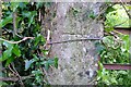
Ordnance Survey Cut Mark
This OS cut mark can be found on a gatepost SE side of the road. It marks a point 146.588m above mean sea level.
Image: © Adrian Dust
Taken: 4 Jun 2021
0.11 miles
5
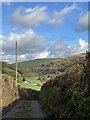
Llwybr uwchlaw Cwmcothi / Path above the Cothi Valley
Llwybr cyhoeddus yn mynd i lawr y waered i gyfeiriad Cwm Cothi.
A public footpath descending towards the Cothi Valley.
Image: © Alan Richards
Taken: 14 May 2021
0.15 miles