IMAGES TAKEN NEAR TO
Rhydargaeau Road, CARMARTHEN, SA32 7JL
Introduction
This page details the photographs taken nearby to Rhydargaeau Road, SA32 7JL by members of the Geograph project.
The Geograph project started in 2005 with the aim of publishing, organising and preserving representative images for every square kilometre of Great Britain, Ireland and the Isle of Man.

There are currently over 7.5m images from over14,400 individuals and you can help contribute to the project by visiting https://www.geograph.org.uk
Image Map
Images are licensed for reuse under creativecommons.org/licenses/by-sa/2.0
Notes
- Clicking on the map will re-center to the selected point.
- The higher the marker number, the further away the image location is from the centre of the postcode.
Image Listing (3 Images Found)
Images are licensed for reuse under creativecommons.org/licenses/by-sa/2.0
Image
Details
Distance
1
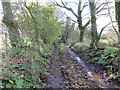
Llwybr Penclyn / Penclyn Path
Heol fynedfa a llwybr cyhoeddus yn mynd i gyfeiriad Penclyn.
An access road and public footpath heading in the direction of Penclyn.
Image: © Alan Richards
Taken: 16 Oct 2019
0.06 miles
2
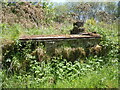
Hen stand laeth / Old milkstand near Pencnwc & Ffynnoniago, Rhydargaeau Road
Image: © David Jones
Taken: 4 Jun 2021
0.14 miles
3
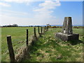
Fence Line View from Bull Hall Farm Triangulation Pillar
Looking south-westward.
Image: © Peter Wood
Taken: 19 Apr 2015
0.18 miles