IMAGES TAKEN NEAR TO
Llanllawddog, CARMARTHEN, SA32 7JD
Introduction
This page details the photographs taken nearby to SA32 7JD by members of the Geograph project.
The Geograph project started in 2005 with the aim of publishing, organising and preserving representative images for every square kilometre of Great Britain, Ireland and the Isle of Man.

There are currently over 7.5m images from over14,400 individuals and you can help contribute to the project by visiting https://www.geograph.org.uk
Image Map (Loading...)


Getting Data...Please wait
Leaflet Map data © OpenStreetMap
Images are licensed for reuse under creativecommons.org/licenses/by-sa/2.0
Notes
- Clicking on the map will re-center to the selected point.
- The higher the marker number, the further away the image location is from the centre of the postcode.
Image Listing (6 Images Found)
Images are licensed for reuse under creativecommons.org/licenses/by-sa/2.0
Image
Details
Distance
1
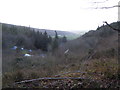
Looking over Cwmrhysifan towards lower Llanllawddog
Image: © David Jones
Taken: 30 Jan 2016
0.01 miles
2
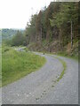
Trac fforest uwchben / Forest track above Cwmrhysifan, Llanllawddog
Image: © David Jones
Taken: 6 Jun 2021
0.07 miles
3

Logging in Brechfa Forest
Piles of logs waiting to be loaded on trailers for transporting away from the forest. The blue and yellow machines can pick up one or more logs at a time, or even whole trees, and manoeuvre them with ease.
Image: © Marion Phillips
Taken: 19 Feb 2009
0.07 miles
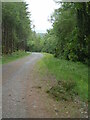
4

Forestry Junction
This is the junction between several forest tracks. The Forestry Commission spreads plenty of crushed stone on these tracks to accommodate the heavy equipment they use. In the distance a mast is just visible on the skyline.
Image: © Marion Phillips
Taken: 19 Feb 2009
0.09 miles
5
Trac fforest ger / Forest track near Cwmrhysifan, Llanllawddog
Image: © David Jones
Taken: 6 Jun 2021
0.10 miles
6
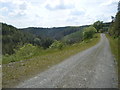
Track, South Brechfa Forest, Llanllawddog
Image: © David Jones
Taken: 21 May 2014
0.15 miles