IMAGES TAKEN NEAR TO
Llanllawddog, CARMARTHEN, SA32 7JB
Introduction
This page details the photographs taken nearby to SA32 7JB by members of the Geograph project.
The Geograph project started in 2005 with the aim of publishing, organising and preserving representative images for every square kilometre of Great Britain, Ireland and the Isle of Man.

There are currently over 7.5m images from over14,400 individuals and you can help contribute to the project by visiting https://www.geograph.org.uk
Image Map
Images are licensed for reuse under creativecommons.org/licenses/by-sa/2.0
Notes
- Clicking on the map will re-center to the selected point.
- The higher the marker number, the further away the image location is from the centre of the postcode.
Image Listing (4 Images Found)
Images are licensed for reuse under creativecommons.org/licenses/by-sa/2.0
Image
Details
Distance
1
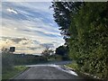
Road junction at dusk
Approaching the A485.
Image: © Alan Hughes
Taken: 4 Nov 2022
0.14 miles
2
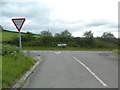
Junction of the road from Llanpumsaint with the A485
Image: © John Lord
Taken: 10 Aug 2013
0.15 miles
3
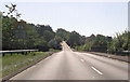
A485 at road junction north of Talybont
Road to right leads to Glan Boncath
Image: © John Firth
Taken: 5 Sep 2012
0.15 miles
4
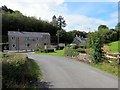
Glanboncath
Heol yn agosau at anhedd-dy o'r enw Glanboncath.
Road approaching a property known as Glanboncath (trans. bank of the boncath (buzzard) stream).
Image: © Alan Richards
Taken: 20 Aug 2014
0.23 miles