IMAGES TAKEN NEAR TO
Whitemill, CARMARTHEN, SA32 7EW
Introduction
This page details the photographs taken nearby to SA32 7EW by members of the Geograph project.
The Geograph project started in 2005 with the aim of publishing, organising and preserving representative images for every square kilometre of Great Britain, Ireland and the Isle of Man.

There are currently over 7.5m images from over14,400 individuals and you can help contribute to the project by visiting https://www.geograph.org.uk
Image Map
Images are licensed for reuse under creativecommons.org/licenses/by-sa/2.0
Notes
- Clicking on the map will re-center to the selected point.
- The higher the marker number, the further away the image location is from the centre of the postcode.
Image Listing (4 Images Found)
Images are licensed for reuse under creativecommons.org/licenses/by-sa/2.0
Image
Details
Distance
1

Pompren Afon Marlais Footbridge
Pompren yn rhychwantu Afon Marlais ger Ffarm Pantyddauddwr.
A footbridge spanning the Marlais Stream near Pantyddauddwr Farm (hollow of the two streams).
Image: © Alan Richards
Taken: 10 Jan 2009
0.14 miles
2
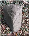
Old Milestone by the A40, east of White Mill, Abergwili parish
Milestone by the A40, in parish of Abergwili (Carmarthenshire District), White Mill, 800m East of village, North side of road.
Inscription once read:-
(Carmarthen 4)
(Llandilo 11)
Carved benchmark and rivet on top.
Surveyed
Milestone Society National ID: CAM_LOCM04
Image: © Milestone Society
Taken: Unknown
0.19 miles
3
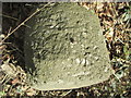
Ordnance Survey Rivet
This OS rivet can be found on the milestone on the north side of the road. It marks a point 15.969m above mean sea level. http://www.geograph.org.uk/photo/4369375
Image: © Adrian Dust
Taken: 1 Mar 2015
0.20 miles
4
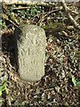
Milestone - Llandeilo 11
There is an Ordnance Survey rivet on the top. http://www.geograph.org.uk/photo/4369372
Image: © Adrian Dust
Taken: 1 Mar 2015
0.20 miles