IMAGES TAKEN NEAR TO
Brechfa, CARMARTHEN, SA32 7BW
Introduction
This page details the photographs taken nearby to SA32 7BW by members of the Geograph project.
The Geograph project started in 2005 with the aim of publishing, organising and preserving representative images for every square kilometre of Great Britain, Ireland and the Isle of Man.

There are currently over 7.5m images from over14,400 individuals and you can help contribute to the project by visiting https://www.geograph.org.uk
Image Map
Images are licensed for reuse under creativecommons.org/licenses/by-sa/2.0
Notes
- Clicking on the map will re-center to the selected point.
- The higher the marker number, the further away the image location is from the centre of the postcode.
Image Listing (4 Images Found)
Images are licensed for reuse under creativecommons.org/licenses/by-sa/2.0
Image
Details
Distance
1
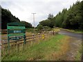
Maes Parcio Keepers Lodge Car Park
Maes Parcio Keepers Lodge ym Mhrechfa.
Keepers Lodge Car Park in Brechfa (trans. mottled place).
Image: © Alan Richards
Taken: 13 Aug 2014
0.07 miles
2
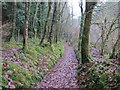
Llwybr Ceffyl Llain Bridleway, Brechfa
Llwybr ceffyl gerllaw anhedd-dy o'r enw Llain / A bridleway near a property known as Llain
Image: © Alan Richards
Taken: 6 Jan 2013
0.11 miles
3
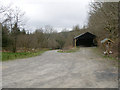
Car Park
Car park on the edge of forestry north of Brechfa.
Image: © Dara Jasumani
Taken: 16 Apr 2006
0.17 miles
4
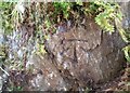
Ordnance Survey Cut Mark
This OS cut mark can be found on the rock outcrop east side of the road. It marks a point 190.910m above mean sea level.
Image: © Adrian Dust
Taken: 4 Jun 2021
0.20 miles