IMAGES TAKEN NEAR TO
Maes Yr Ysgol, CARMARTHEN, SA32 7BT
Introduction
This page details the photographs taken nearby to Maes Yr Ysgol, SA32 7BT by members of the Geograph project.
The Geograph project started in 2005 with the aim of publishing, organising and preserving representative images for every square kilometre of Great Britain, Ireland and the Isle of Man.

There are currently over 7.5m images from over14,400 individuals and you can help contribute to the project by visiting https://www.geograph.org.uk
Image Map (Loading...)


Getting Data...Please wait
Leaflet Map data © OpenStreetMap
Images are licensed for reuse under creativecommons.org/licenses/by-sa/2.0
Notes
- Clicking on the map will re-center to the selected point.
- The higher the marker number, the further away the image location is from the centre of the postcode.
Image Listing (59 Images Found)
Images are licensed for reuse under creativecommons.org/licenses/by-sa/2.0
Image
Details
Distance
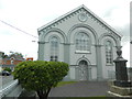
1
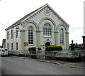
Chapel
Peniel Chapel from the junction with the A485.
Image: © Dara Jasumani
Taken: 15 Apr 2006
0.02 miles
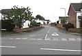
2
Maes yr Ysgol, Peniel, Carmarthenshire
Viewed from the edge of the village school. Maes yr Ysgol leads to the cul-de-sac Bro'r Hengil.
Image: © Jaggery
Taken: 2 Oct 2019
0.04 miles
3
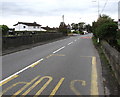
South along the A485, Peniel, Carmarthenshire
The A485 is the main road through Peniel. Ahead for Carmarthen.
Image: © Jaggery
Taken: 2 Oct 2019
0.04 miles
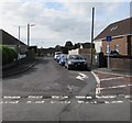
4
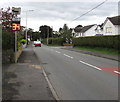
Vehicle speed indicator, Peniel, Carmarthenshire
Facing southbound traffic on the A485, the main road through Peniel.
The display illuminates to show the speed of an approaching vehicle.
The display is green if the speed is within the speed limit
or red if over the speed limit, as here.
Image: © Jaggery
Taken: 2 Oct 2019
0.04 miles
5
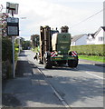
Krone Big M Mower in Peniel, Carmarthenshire
Agricultural vehicle travelling south on the A485, the main road through Peniel.
Image: © Jaggery
Taken: 2 Oct 2019
0.04 miles
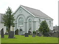
6
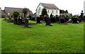
Cemetery in Peniel, Carmarthenshire
On the south side of Peniel Chapel https://www.geograph.org.uk/photo/6286146 in the background on the right.
Image: © Jaggery
Taken: 2 Oct 2019
0.05 miles
7
Junction of Maes Brynglas and the A485, Peniel, Carmarthenshire
Viewed across the A485, the main road through Peniel.
Image: © Jaggery
Taken: 2 Oct 2019
0.05 miles
8
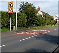
Warning signs alongside the A485, Peniel, Carmarthenshire
Facing northbound traffic on the main road through Peniel. The village school is nearby.
Image: © Jaggery
Taken: 2 Oct 2019
0.05 miles