IMAGES TAKEN NEAR TO
Abergorlech Road, CARMARTHEN, SA32 7BD
Introduction
This page details the photographs taken nearby to Abergorlech Road, SA32 7BD by members of the Geograph project.
The Geograph project started in 2005 with the aim of publishing, organising and preserving representative images for every square kilometre of Great Britain, Ireland and the Isle of Man.

There are currently over 7.5m images from over14,400 individuals and you can help contribute to the project by visiting https://www.geograph.org.uk
Image Map
Images are licensed for reuse under creativecommons.org/licenses/by-sa/2.0
Notes
- Clicking on the map will re-center to the selected point.
- The higher the marker number, the further away the image location is from the centre of the postcode.
Image Listing (2 Images Found)
Images are licensed for reuse under creativecommons.org/licenses/by-sa/2.0
Image
Details
Distance
1
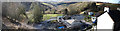
Renovations and Re-building
This property is below a tight curve in the road.
Taken looking NW.
Image: © Dara Jasumani
Taken: 9 Apr 2006
0.14 miles
2
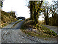
Entrance
Entrance to the property Tir Walter shown on the OS as Tirwalter.
I think this translates as Walter's land.
Image: © Dara Jasumani
Taken: 9 Apr 2006
0.18 miles