IMAGES TAKEN NEAR TO
Heol Penllain, CARMARTHEN, SA32 7AT
Introduction
This page details the photographs taken nearby to Heol Penllain, SA32 7AT by members of the Geograph project.
The Geograph project started in 2005 with the aim of publishing, organising and preserving representative images for every square kilometre of Great Britain, Ireland and the Isle of Man.

There are currently over 7.5m images from over14,400 individuals and you can help contribute to the project by visiting https://www.geograph.org.uk
Image Map
Images are licensed for reuse under creativecommons.org/licenses/by-sa/2.0
Notes
- Clicking on the map will re-center to the selected point.
- The higher the marker number, the further away the image location is from the centre of the postcode.
Image Listing (52 Images Found)
Images are licensed for reuse under creativecommons.org/licenses/by-sa/2.0
Image
Details
Distance
1
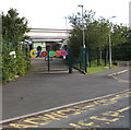
Colourful Welsh welcome on the village school gates, Peniel, Carmarthenshire
Croeso is on the gates at the entrance to Ysgol Gymunedol Peniel located in a rural area about 5km north of Carmarthen. The school which was opened in September 2009 serves Peniel and the neighbouring villages of Bronwydd, Rhydargaeau and Pont-ar-Sais.
Image: © Jaggery
Taken: 2 Oct 2019
0.04 miles
2
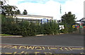
South side of Ysgol Gymunedol Peniel, Carmarthenshire
Welsh-medium primary school in Peniel. The school was opened in September 2009 to serve Peniel and the neighbouring villages of Bronwydd, Rhydargaeau and Pont-ar-Sais.
A colourful Welsh welcome is on the right. https://www.geograph.org.uk/photo/6286158
Image: © Jaggery
Taken: 2 Oct 2019
0.06 miles
3
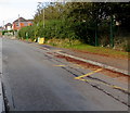
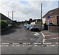
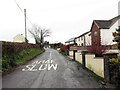
Zigzag road markings near the village school, Peniel, Carmarthenshire
The yellow markings are faded in October 2019. A nearby sign states
No stopping Mon - Fri 8am - 6pm on school entrance markings.
Image: © Jaggery
Taken: 2 Oct 2019
0.06 miles
4
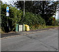
Cabinets and bins alongside the road to the village school, Peniel, Carmarthenshire
Near a Welsh/English sign showing Unffordd/One way.
Image: © Jaggery
Taken: 2 Oct 2019
0.07 miles
5
Maes yr Ysgol, Peniel, Carmarthenshire
Viewed from the edge of the village school. Maes yr Ysgol leads to the cul-de-sac Bro'r Hengil.
Image: © Jaggery
Taken: 2 Oct 2019
0.07 miles
6
Y Cam Cynta, Peniel, Carmarthenshire
Children's day nursery located opposite the village school.
Image: © Jaggery
Taken: 2 Oct 2019
0.07 miles
7
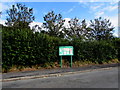
Abergwili Community Council noticeboard in Peniel, Carmarthenshire
Green noticeboard on the approach to the village school. https://www.geograph.org.uk/photo/6286170
Abergwili Community Council is one of seventy-two Town and Community Councils in Carmarthenshire in 2019.
Image: © Jaggery
Taken: 2 Oct 2019
0.08 miles
8
Cyrraedd Peniel / Arriving at Peniel
Heol fach yn cyrraedd pentre Peniel.
A minor road entering the village of Peniel.
Image: © Alan Richards
Taken: 5 Jan 2023
0.08 miles
9
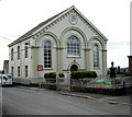
Chapel
Peniel Chapel from the junction with the A485.
Image: © Dara Jasumani
Taken: 15 Apr 2006
0.10 miles
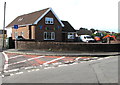
10
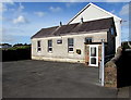
SM9 Fitness, Peniel, Carmarthenshire
Fitness centre located in Yr Hen Ysgol (Welsh for The Old School).
Image: © Jaggery
Taken: 2 Oct 2019
0.10 miles