IMAGES TAKEN NEAR TO
Peniel, CARMARTHEN, SA32 7AQ
Introduction
This page details the photographs taken nearby to SA32 7AQ by members of the Geograph project.
The Geograph project started in 2005 with the aim of publishing, organising and preserving representative images for every square kilometre of Great Britain, Ireland and the Isle of Man.

There are currently over 7.5m images from over14,400 individuals and you can help contribute to the project by visiting https://www.geograph.org.uk
Image Map
Images are licensed for reuse under creativecommons.org/licenses/by-sa/2.0
Notes
- Clicking on the map will re-center to the selected point.
- The higher the marker number, the further away the image location is from the centre of the postcode.
Image Listing (3 Images Found)
Images are licensed for reuse under creativecommons.org/licenses/by-sa/2.0
Image
Details
Distance
1
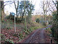
Llwybr ger Felin Gelli / Path near Felin Gelli
Llwybr cyhoeddus yn gadael heol fach ger anhedd-dy o'r enw Felin Gelli.
A public footpath exiting a road near a property known as Felin Gelli (trans. mill grove).
Image: © Alan Richards
Taken: 29 Nov 2019
0.04 miles
2
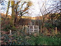
Llwybr Llwyn Martin Isaf / Llwyn Martin Isaf Path
Llwybr cyhoeddus yn mynd i gyfeiriad Llwyn Martin Isaf.
A public footpath heading towards Llwyn Martin Isaf (trans. Martin's grove [lower farm]).
Image: © Alan Richards
Taken: 29 Nov 2019
0.07 miles
3
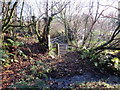
Llwybr Llwyn Martin Uchaf / Llwyn Martin Uchaf Path
Llwybr cyhoeddus yn agosau at Ffarm Llwyn Martin Uchaf.
A public footpath approaching Llwyn Martin Uchaf (Martin's grove [upper farm]).
Image: © Alan Richards
Taken: 29 Nov 2019
0.19 miles