IMAGES TAKEN NEAR TO
Peniel, CARMARTHEN, SA32 7AG
Introduction
This page details the photographs taken nearby to SA32 7AG by members of the Geograph project.
The Geograph project started in 2005 with the aim of publishing, organising and preserving representative images for every square kilometre of Great Britain, Ireland and the Isle of Man.

There are currently over 7.5m images from over14,400 individuals and you can help contribute to the project by visiting https://www.geograph.org.uk
Image Map
Images are licensed for reuse under creativecommons.org/licenses/by-sa/2.0
Notes
- Clicking on the map will re-center to the selected point.
- The higher the marker number, the further away the image location is from the centre of the postcode.
Image Listing (5 Images Found)
Images are licensed for reuse under creativecommons.org/licenses/by-sa/2.0
Image
Details
Distance
1
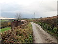
Heol ger Hengil Fach / Road near Hengil Fach
Heol fach yn mynd heibio i hen sied sinc ger Farm Hengil Fach.
A minor road passing an old zinc shed near Hengil Farm.
Image: © Alan Richards
Taken: 27 Nov 2019
0.10 miles
3
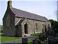
Capel y Groes, Peniel / Church of the Holy Cross, Peniel
Capel y Groes, capel anwes i Abergwili. Yr enw lleol arno yw'r Eglwys Fach. Fe'i hadeiladwyd yn 1887 ar safle hen gapel. Mae carreg endoredig a darganfuwyd yma i'w gweld bellach yn Amgueddfa Caerfyrddin. Caewyd yr addoldy yn anffodus yn 2011 ac mae'r adeilad bellach yn ganolfan hydrotherapi ciol.
Capel y Groes (trans. chapel of the cross), a chapel of ease belonging to Abergwili. Known locally as yr Eglwys Fach (the little church) it was constructed in 1887 on the site of an earlier chapel. An incised cross discovered here is now on display at Carmarthen Museum. Sadly, the church finally closed its doors for worship in 2011. Today, the building is a canine hydrotherapy centre.
Image: © Alan Richards
Taken: 27 Nov 2019
0.16 miles
4
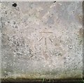
Ordnance Survey Cut Mark
This OS cut mark can be found on the churn stand north side of the road. It marks a point 100.409m above mean sea level.
Image: © Adrian Dust
Taken: 24 Oct 2019
0.17 miles
5
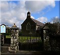
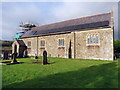
Gateway to Eglwys Capel y Groes
There is a nice stile just to the left of the gate, which is fortunate as looking through the windows the Chapel appears to be no longer in use and the gate is padlocked. Eglwys Capel y Groes translates to Chapel of the Cross Church
Image: © frank cokayne
Taken: 5 Mar 2012
0.18 miles