IMAGES TAKEN NEAR TO
Port Eynon, SWANSEA, SA3 1PD
Introduction
This page details the photographs taken nearby to SA3 1PD by members of the Geograph project.
The Geograph project started in 2005 with the aim of publishing, organising and preserving representative images for every square kilometre of Great Britain, Ireland and the Isle of Man.

There are currently over 7.5m images from over14,400 individuals and you can help contribute to the project by visiting https://www.geograph.org.uk
Image Map
Images are licensed for reuse under creativecommons.org/licenses/by-sa/2.0
Notes
- Clicking on the map will re-center to the selected point.
- The higher the marker number, the further away the image location is from the centre of the postcode.
Image Listing (8 Images Found)
Images are licensed for reuse under creativecommons.org/licenses/by-sa/2.0
Image
Details
Distance
1

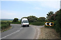
Margam Farm
Margam Farm on the bend in the B4247 between Scurlage and Knelston.
Image: © Alan Hughes
Taken: 21 Feb 2019
0.00 miles
2
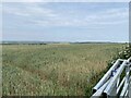
Rhossili Community: corner near Margam Farm
Looking east-south-east. Behind the camera the road leads to Rhossili. On the boundary with Port Eynon Community
Image: © Martin Bodman
Taken: 10 Jun 2006
0.02 miles
5

Pylewell Farm
A sheep takes a break from grazing to pose for the camera.
Image: © Alan Hughes
Taken: 21 Feb 2019
0.21 miles
6
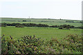
Rhossili Community: near Paviland Manor
Looking south-south-east over farmland
Image: © Martin Bodman
Taken: 10 Jun 2006
0.25 miles
7

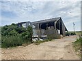
Pond and farmhouse
View across farmland towards Pylewell Farm.
Image: © Alan Hughes
Taken: 21 Feb 2019
0.25 miles
8
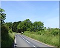
Trees at a bend in the B4247
There are two footpaths at this bend making it effectively a crossroads
Image: © David Smith
Taken: 3 Jun 2018
0.25 miles