IMAGES TAKEN NEAR TO
Port Eynon, SWANSEA, SA3 1NP
Introduction
This page details the photographs taken nearby to SA3 1NP by members of the Geograph project.
The Geograph project started in 2005 with the aim of publishing, organising and preserving representative images for every square kilometre of Great Britain, Ireland and the Isle of Man.

There are currently over 7.5m images from over14,400 individuals and you can help contribute to the project by visiting https://www.geograph.org.uk
Image Map
Images are licensed for reuse under creativecommons.org/licenses/by-sa/2.0
Notes
- Clicking on the map will re-center to the selected point.
- The higher the marker number, the further away the image location is from the centre of the postcode.
Image Listing (29 Images Found)
Images are licensed for reuse under creativecommons.org/licenses/by-sa/2.0
Image
Details
Distance
1
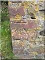
Ordnance Survey Cut Mark
This OS cut mark can be found on a wall to the east of the road. It marks a point 58.037m above mean sea level.
Image: © Adrian Dust
Taken: 7 Jun 2014
0.05 miles
3
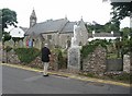
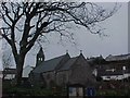
Port Eynon Church
The memorial in the photo is to 3 Lifeboat men who lost their lives when the lifeboat went down in 1916. Port Eynon no longer has a lifeboat and the old lifeboat station is now a Youth Hostel.
Image: © Ruth Jowett
Taken: Unknown
0.14 miles
4
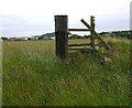
Old stile
Above Overton on The Gower. Many more in better condition to go.
Image: © John Duckfield
Taken: 24 Jul 2011
0.15 miles
5
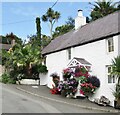
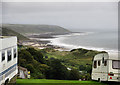
Port Eynon
Palm trees and roses round the door on the Gower Peninsula.
Image: © Colin Smith
Taken: 4 Sep 2018
0.16 miles
6
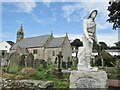
Port Eynon - Church
St Cattwg was a Welsh saint born c497AD and the present church dates from the mid-19th century. In the foreground is the lifeboatmen memorial.
Image: © Colin Smith
Taken: 4 Sep 2018
0.17 miles
7
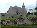
St.Cattwg's Church
St.Cattwg's Church, Port Eynon.
Image: © Alan Hughes
Taken: 14 Aug 2017
0.17 miles
8
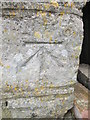
Ordnance Survey Cut Mark
This OS cut mark can be found on the porch of St Cadoc's Church. It marks a point 20.089m above mean sea level. http://www.geograph.org.uk/photo/4017100
Image: © Adrian Dust
Taken: 7 Jun 2014
0.17 miles
10
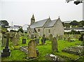
Port-Eynon, St. Cattwg's
Parish church with C12 roots, heavily restored in the Victorian era.
Image: © Mike Faherty
Taken: 16 Jul 2016
0.18 miles