IMAGES TAKEN NEAR TO
St. Peters, CARMARTHEN, SA31 3RR
Introduction
This page details the photographs taken nearby to SA31 3RR by members of the Geograph project.
The Geograph project started in 2005 with the aim of publishing, organising and preserving representative images for every square kilometre of Great Britain, Ireland and the Isle of Man.

There are currently over 7.5m images from over14,400 individuals and you can help contribute to the project by visiting https://www.geograph.org.uk
Image Map (Loading...)


Getting Data...Please wait
Leaflet Map data © OpenStreetMap
Images are licensed for reuse under creativecommons.org/licenses/by-sa/2.0
Notes
- Clicking on the map will re-center to the selected point.
- The higher the marker number, the further away the image location is from the centre of the postcode.
Image Listing (3 Images Found)
Images are licensed for reuse under creativecommons.org/licenses/by-sa/2.0
Image
Details
Distance
1
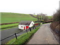
Heol fynedfa Cwmau Bach / Cwmau Bach access road
Heol fynedfa yn mynd heibio i dŷ mas Melin Trebersed, cyn felin lafur.
An access road passing an outhouse of Melin Trebersed, a former corn mill.
Image: © Alan Richards
Taken: 1 Jan 2023
0.01 miles
2
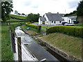
Melin Trebersed
The stream (Nant-y-ci), now diverted, used to power the water wheel for the old corn mill on the right.
Image: © Gethin Evans
Taken: 28 May 2007
0.01 miles
3
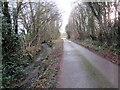
Nant ac heol / Stream and road
Yn y lleoliad hwn mae Nant y Ci yn rhedeg yn gyfochrog â heol fach
At this location Nant y Ci (trans. stream of the dog) runs parallel with a minor road.
Image: © Alan Richards
Taken: 1 Jan 2023
0.20 miles