IMAGES TAKEN NEAR TO
Heol Morfa Brenin, CARMARTHEN, SA31 3PA
Introduction
This page details the photographs taken nearby to Heol Morfa Brenin, SA31 3PA by members of the Geograph project.
The Geograph project started in 2005 with the aim of publishing, organising and preserving representative images for every square kilometre of Great Britain, Ireland and the Isle of Man.

There are currently over 7.5m images from over14,400 individuals and you can help contribute to the project by visiting https://www.geograph.org.uk
Image Map
Images are licensed for reuse under creativecommons.org/licenses/by-sa/2.0
Notes
- Clicking on the map will re-center to the selected point.
- The higher the marker number, the further away the image location is from the centre of the postcode.
Image Listing (10 Images Found)
Images are licensed for reuse under creativecommons.org/licenses/by-sa/2.0
Image
Details
Distance
1
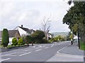
Llansteffan Road
The B4312 south of Carmarthen near to the River Towy.
Image: © Gordon Griffiths
Taken: 23 Sep 2011
0.09 miles
2
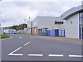
Carmarthen Leisure Centre
The centre alongside the B4312 which backs on to the River Towy.
Image: © Gordon Griffiths
Taken: 23 Sep 2011
0.16 miles
3
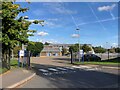
Queen Elizabeth High School, Carmarthen
Image: © Eirian Evans
Taken: 23 Sep 2022
0.16 miles
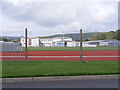
4
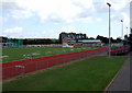
Running track and school
The running track belongs to the Leisure Centre which is just out of the picture to the left, with a school on either side - one visible here to the right.
Image: © Natasha Ceridwen de Chroustchoff
Taken: 19 May 2007
0.17 miles
5
Queen Elizabeth School
The Comprehensive High School on Llansteffan Road, Carmarthen.
Image: © Gordon Griffiths
Taken: 23 Sep 2011
0.18 miles
6
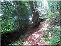
Coed yr Ystrad / Ystrad Wood
Llwybr yng Nghoed yr Ystrad, coedwig sydd o dan ofal Coed Cadw.
A footpath in Ystrad Wood (trans. vale), a woodland under the care of Coed Cadw.
Image: © Alan Richards
Taken: 1 Aug 2018
0.19 miles
7
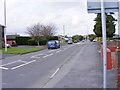
Road View
The B4312 south of Carmarthen viewed from the Spar car park.
Image: © Gordon Griffiths
Taken: 23 Sep 2011
0.22 miles
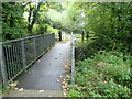
9
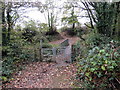
Llwybr Arfordir Cymru / Wales Coastal Path
Gât fochyn a phontdroed ar Lwybr Arfordir Cymru ger Rhyd y Gors.
A kissing gate and footbridge on the Wales Coastal Path near Rhyd y Gors (trans. ford of the fen).
Image: © Alan Richards
Taken: 4 Nov 2018
0.23 miles
10
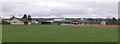
Sports pavilion
Bordered by Alltycnap Road and the B4312 at Johnstown Carmarthen, there are no goal posts etc visible so maybe a cricket ground?
Image: © chris whitehouse
Taken: 8 Nov 2012
0.25 miles