IMAGES TAKEN NEAR TO
Llwyn Yr Eos, CARMARTHEN, SA31 3GH
Introduction
This page details the photographs taken nearby to Llwyn Yr Eos, SA31 3GH by members of the Geograph project.
The Geograph project started in 2005 with the aim of publishing, organising and preserving representative images for every square kilometre of Great Britain, Ireland and the Isle of Man.

There are currently over 7.5m images from over14,400 individuals and you can help contribute to the project by visiting https://www.geograph.org.uk
Image Map
Images are licensed for reuse under creativecommons.org/licenses/by-sa/2.0
Notes
- Clicking on the map will re-center to the selected point.
- The higher the marker number, the further away the image location is from the centre of the postcode.
Image Listing (6 Images Found)
Images are licensed for reuse under creativecommons.org/licenses/by-sa/2.0
Image
Details
Distance
1
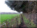
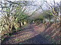
Llwybr i Drefechan / Path to Trevaughan
Llwybr cyhoeddus yn mynd i gyfeiriad pentre Trefechan.
A public footpath heading in the direction of Trevaughan < Trefechan (trans. small town).
Image: © Alan Richards
Taken: 12 Jan 2023
0.05 miles
2
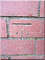
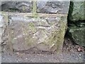
Ordnance Survey Cut Mark
This OS cut mark can be found on the wall between No15 & No16 College Road. It marks a point 42.971m above mean sea level.
Image: © Adrian Dust
Taken: 25 Jan 2014
0.17 miles
3
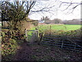
Llwybr i Gaerfyrddin / Path to Carmarthen
Llwybr cyhoeddus yn mynd i gyfeiriad Caerfyrddin.
A public footpath heading towards Carmarthen.
Image: © Alan Richards
Taken: 12 Jan 2023
0.18 miles
4
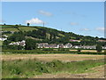
Trevaughan Road and Elim Road, Carmarthen
Looking towards Trevaughan Road and Elim Road, taken from the fields off College Road, Carmarthen.
Image: © John Dalling
Taken: 15 Jun 2008
0.20 miles
5
Llwybr i Drefechan / Path to Trevaughan
Llwybr cyhoeddus yn mynd i gyfeiriad pentre Trefechan.
A public footpath heading in the direction of Trevaughen < Trefechan (trans. small town).
Image: © Alan Richards
Taken: 12 Jan 2023
0.21 miles
6
Ordnance Survey Cut Mark
This OS cut mark can be found on the wall post at the entrance to the College on College Road. It marks a point 41.253m above mean sea level.
Image: © Adrian Dust
Taken: 13 Dec 2021
0.22 miles