IMAGES TAKEN NEAR TO
Lon Ty Cwm, CARMARTHEN, SA31 3GA
Introduction
This page details the photographs taken nearby to Lon Ty Cwm, SA31 3GA by members of the Geograph project.
The Geograph project started in 2005 with the aim of publishing, organising and preserving representative images for every square kilometre of Great Britain, Ireland and the Isle of Man.

There are currently over 7.5m images from over14,400 individuals and you can help contribute to the project by visiting https://www.geograph.org.uk
Image Map (Loading...)


Getting Data...Please wait
Leaflet Map data © OpenStreetMap
Images are licensed for reuse under creativecommons.org/licenses/by-sa/2.0
Notes
- Clicking on the map will re-center to the selected point.
- The higher the marker number, the further away the image location is from the centre of the postcode.
Image Listing (8 Images Found)
Images are licensed for reuse under creativecommons.org/licenses/by-sa/2.0
Image
Details
Distance
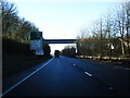
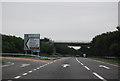
1
B4312 approaching Carmarthen
This section is part of the original road from Carmarthen to St.Clears.
Image: © Alan Hughes
Taken: 1 Sep 2017
0.15 miles
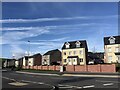
2
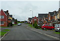
Allt Ioan
A new housing development at the very western edge of Carmarthen.
Image: © Jonathan Billinger
Taken: 15 Oct 2008
0.15 miles
4
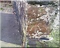
Ordnance Survey Cut Mark
This OS cut mark can be found on the barn at Penybont Farm on Millbank Road. It marks a point 12.148m above mean sea level.
Image: © Adrian Dust
Taken: 13 Dec 2021
0.17 miles
5

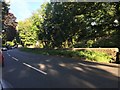
The B4312 heading for Carmarthen
A view of a section of the tree-lined B4312 through Johnstown heading for Monument Hill and Carmarthen.
Image: © Martyn Harries
Taken: 11 Apr 2012
0.18 miles
6
Maes Macsen houses
New housing estate in Llanllwch
Image: © Eirian Evans
Taken: 23 Sep 2022
0.20 miles
8
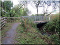
Pontdroed / Footbridge
Pontdroed yn rhychwantu nant dienw.
A footbridge spanning an unnamed stream.
Image: © Alan Richards
Taken: 1 Aug 2018
0.21 miles