IMAGES TAKEN NEAR TO
Ash Grove, SA31 3FE
Introduction
This page details the photographs taken nearby to Ash Grove, SA31 3FE by members of the Geograph project.
The Geograph project started in 2005 with the aim of publishing, organising and preserving representative images for every square kilometre of Great Britain, Ireland and the Isle of Man.

There are currently over 7.5m images from over14,400 individuals and you can help contribute to the project by visiting https://www.geograph.org.uk
Image Map (Loading...)


Getting Data...Please wait
Leaflet Map data © OpenStreetMap
Images are licensed for reuse under creativecommons.org/licenses/by-sa/2.0
Notes
- Clicking on the map will re-center to the selected point.
- The higher the marker number, the further away the image location is from the centre of the postcode.
Image Listing (26 Images Found)
Images are licensed for reuse under creativecommons.org/licenses/by-sa/2.0
Image
Details
Distance
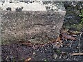
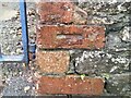
1
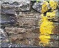
Ordnance Survey Cut Mark
This OS cut mark can be found on the wall of No1 Jobs Well Road. It marks a point 11.712m above mean sea level.
Image: © Adrian Dust
Taken: 13 Dec 2021
0.04 miles
2
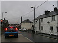
Two storey old Toll House
Waiting at the traffic lights in the rain, the building, centre, was a Toll House, but two storeys high! British Listed buildings ref 9577, junction Job's Well Road with Monument Hill.
Image: © chris whitehouse
Taken: 14 Dec 2012
0.08 miles
3
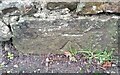
Ordnance Survey Cut Mark
This OS cut mark can be found on the wall NW side of St Clears Road. It marks a point 7.394m above mean sea level.
Image: © Adrian Dust
Taken: 13 Dec 2021
0.15 miles
4
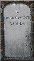
Old Milestone by the B4312, Monument Hill, Carmarthen parish
Stone post by the B4312, in parish of Carmarthen (Carmarthenshire District), Monument Hill, midway down Monument Hill, inset into wall, north side of road.
inscription reads:-
To
HOBB'S POINT
32
Miles
Grade II listed by Cadw.
Reference Number: 9504 https://cadwpublic-api.azurewebsites.net/reports/listedbuilding/FullReport?lang=&id=9504
Surveyed
Milestone Society National ID: CAM_CMHP01
Image: © Milestone Society
Taken: Unknown
0.16 miles
5
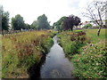
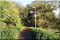
Nant Tawelan / Tawelan Brook
Nant Tawelan yn Nhre Ioan.
Tawelan Brook at Johnstown.
Image: © Alan Richards
Taken: 1 Aug 2018
0.17 miles
6
Ordnance Survey Cut Mark
This OS cut mark can be found on Jobs Well House on Jobs Well Road. It marks a point 29.910m above mean sea level.
Image: © Adrian Dust
Taken: 13 Dec 2021
0.18 miles
7
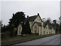
Jobswell House
Mansion that gives its name to the adjoining Jobswell Road. Now used by the West Wales Substance Misuse Service and the local NHS Trust Family Support Team. The once fine gardens below the house are now given over to brambles.
Image: © Marion Phillips
Taken: 4 Jan 2009
0.18 miles
8
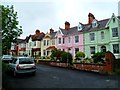
Colourful houses, Penllwyn Park, Carmarthen
Located on the north side of the B4312, near Picton's Monument. http://www.geograph.org.uk/photo/2597198
Image: © Jaggery
Taken: 3 Jun 2012
0.19 miles
10
Ordnance Survey Cut Mark
This OS cut mark can be found on the gatepost of No13 Llanstephan Road. It marks a point 5.828m above mean sea level.
Image: © Adrian Dust
Taken: 13 Dec 2021
0.21 miles