IMAGES TAKEN NEAR TO
Heol Arfryn, CARMARTHEN, SA31 3EY
Introduction
This page details the photographs taken nearby to Heol Arfryn, SA31 3EY by members of the Geograph project.
The Geograph project started in 2005 with the aim of publishing, organising and preserving representative images for every square kilometre of Great Britain, Ireland and the Isle of Man.

There are currently over 7.5m images from over14,400 individuals and you can help contribute to the project by visiting https://www.geograph.org.uk
Image Map
Images are licensed for reuse under creativecommons.org/licenses/by-sa/2.0
Notes
- Clicking on the map will re-center to the selected point.
- The higher the marker number, the further away the image location is from the centre of the postcode.
Image Listing (6 Images Found)
Images are licensed for reuse under creativecommons.org/licenses/by-sa/2.0
Image
Details
Distance
1
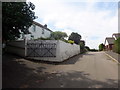
Heol Pentremeurig / Pentremeurig Road
Anhedd-dy ar Heol Pentremeurig.
A property on Pentremeurig Road (trans. Meurig's chief homestead).
Image: © Alan Richards
Taken: 1 Aug 2018
0.09 miles
2
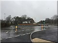
Roundabout
Roundabout at Pentremeurig Road, Carmarthen on a wet autumn day.
Image: © Alan Hughes
Taken: 20 Nov 2017
0.19 miles
3
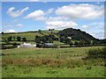
Tre-fechan fach farm
Trevaughan House in background.Pic taken from lane known locally as Tobacco lane.
Image: © John Duckfield
Taken: 13 Aug 2009
0.19 miles
4
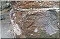
Ordnance Survey Cut Mark
This damaged OS cut mark can be found on the Hospital Lodge. It marks a point 47.850m above mean sea level.
Image: © Adrian Dust
Taken: 13 Dec 2021
0.21 miles
5
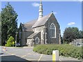
Church within the former Saint David's Mental Hospital
The secure unit has moved to the edge of the facility and the old buildings, like this church, are largely disused.
Image: © Nigel Davies
Taken: 8 Aug 2005
0.22 miles
6
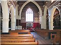
Interior of church at former St David's Mental Hospital
The church and its interior are listed. The upper walls of the church have an unusual brickwork mosaic.
Image: © Nigel Davies
Taken: 8 Aug 2005
0.22 miles