IMAGES TAKEN NEAR TO
St. Catherine Street, CARMARTHEN, SA31 3DY
Introduction
This page details the photographs taken nearby to St. Catherine Street, SA31 3DY by members of the Geograph project.
The Geograph project started in 2005 with the aim of publishing, organising and preserving representative images for every square kilometre of Great Britain, Ireland and the Isle of Man.

There are currently over 7.5m images from over14,400 individuals and you can help contribute to the project by visiting https://www.geograph.org.uk
Image Map (Loading...)


Getting Data...Please wait
Leaflet Map data © OpenStreetMap
Images are licensed for reuse under creativecommons.org/licenses/by-sa/2.0
Notes
- Clicking on the map will re-center to the selected point.
- The higher the marker number, the further away the image location is from the centre of the postcode.
Image Listing (414 Images Found)
Images are licensed for reuse under creativecommons.org/licenses/by-sa/2.0
Image
Details
Distance
1
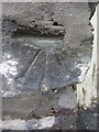
Ordnance Survey Cut Mark
This damaged OS cut mark can be found on the wall of No38 St Catherine Street. It marks a point 18.798m above mean sea level.
Image: © Adrian Dust
Taken: 25 Jan 2014
0.02 miles
2
Oriental China takeaway, Carmarthen
72 Water Street.
Image: © Jaggery
Taken: 12 Aug 2012
0.02 miles
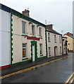
3
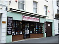
Waverley Stores in Lammas Street
A long-established health food shop run by the same family for 3 generations.
Image: © Natasha Ceridwen de Chroustchoff
Taken: 22 Sep 2010
0.03 miles
4
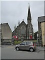
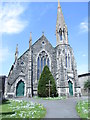
English Congregational Church
The English Congregational Church on Lammas Street in Carmarthen. The church was built in 1861 and designed by Poulton and Woodman. The church is Grade II listed.
Image: © Philip Halling
Taken: 16 Jun 2021
0.04 miles
5
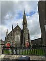
English Congregational Church - Lammas Street
Built 1861/1862
Image: © Betty Longbottom
Taken: 7 May 2013
0.04 miles
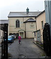
7
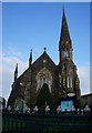
English Congregational Church, Lammas Street, Carmarthen
Image: © Ian S
Taken: 21 Jan 2015
0.05 miles
8
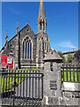
English Congregational Church - Lammas Street, Carmarthen
"The English Congregational Chapel was built in 1861-2 to the design of Poulton & Woodman of Reading, in a Gothic style to a gable-entry plan. It is built from rock-faced rubble stone with ashlar dressings, with angle- and stepped buttresses, and a steep slate roof with coped gable and crested ridge tiles. To the right of the front elevation is an extravagant slender tower with sharp ashlar spire topped by a weathervane. The side walls are of six bays, with pointed single-light windows between buttresses and chamfered stone eaves. The rear gable is masked by a single storey schoolroom." from https://coflein.gov.uk/en/site/6235/.
Image: © Jeff Gogarty
Taken: 24 Apr 2021
0.05 miles
9
Grade II listed Capel Heol Dwr, Carmarthen
The chapel is set back 25 metres from Water Street. The first chapel here was built in 1771.
This chapel is the 1831 rebuild of an 1813 rebuild of the original.
The chapel was Grade II listed in May 1981.
Image: © Jaggery
Taken: 12 Aug 2012
0.05 miles
10
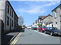
St David's Street - St Catherine Street
Image: © Betty Longbottom
Taken: 7 May 2013
0.05 miles