IMAGES TAKEN NEAR TO
Friars Park, CARMARTHEN, SA31 3AN
Introduction
This page details the photographs taken nearby to Friars Park, SA31 3AN by members of the Geograph project.
The Geograph project started in 2005 with the aim of publishing, organising and preserving representative images for every square kilometre of Great Britain, Ireland and the Isle of Man.

There are currently over 7.5m images from over14,400 individuals and you can help contribute to the project by visiting https://www.geograph.org.uk
Image Map (Loading...)


Getting Data...Please wait
Leaflet Map data © OpenStreetMap
Images are licensed for reuse under creativecommons.org/licenses/by-sa/2.0
Notes
- Clicking on the map will re-center to the selected point.
- The higher the marker number, the further away the image location is from the centre of the postcode.
Image Listing (706 Images Found)
Images are licensed for reuse under creativecommons.org/licenses/by-sa/2.0
Image
Details
Distance
1
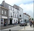
Boar's Head Hotel, Carmarthen
Located at 120 Lammas Street in the centre of Carmarthen.
Probably dating from the late seventeenth or early eighteenth century, extended in the 1750s and the 1820s. Grade II listed in 1981.
Image: © Jaggery
Taken: 30 May 2011
0.01 miles
2
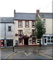
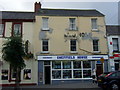
Rose and Crown, Carmarthen
Viewed from Mansel Street. Rose and Crown is a Lammas Street
pub and restaurant with eight en-suite guest rooms.
Next door on the right is Sheffield House, ironmongers.
Image: © Jaggery
Taken: 12 Aug 2012
0.01 miles
3

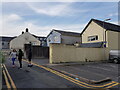
Mural on wall of "drmz" building
Carmarthen Youth Project, the building previously was a gymnasium. The "no through road" terminates here into a small car park, then a foot path behind the Police Station and Wilkinsons store.
Image: © chris whitehouse
Taken: 8 Oct 2012
0.03 miles
4

Sign at entrance to the "drmz" building
See Image for the mural. Carmarthen Youth Project.
Image: © chris whitehouse
Taken: 8 Oct 2012
0.03 miles
5
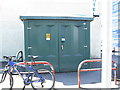
Electricity Substation No 581985 - off Lammas Street
Image: © Betty Longbottom
Taken: 7 May 2013
0.03 miles
6
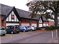
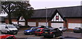
Cwrt - y - Brodyr
This building is Wilkinsons, but it was built by Tesco some years ago, amid some controversy as the site was Friars Park and could be classed as a religious site, I assume there was an archaeological investigation at the time, but what artifacts were discovered I do not know. December 2012: enquired at Carmarthen Museum about the site excavations, and yes artifacts were found and they are on show in the museum.
Image: © chris whitehouse
Taken: 9 Oct 2012
0.03 miles
7
Ironmongers in Lammas Street
Just a fragmentary ghost of the name Sheffield House discernible across the frontage.
Image: © Natasha Ceridwen de Chroustchoff
Taken: 22 Sep 2010
0.03 miles
8
The Bulwarks, Carmarthen
Police station grounds, and a problem for the mower!
Image: © chris whitehouse
Taken: 8 Oct 2012
0.03 miles
10
Friars Park
The English end of the store showing the inscription in English, but why is the Heraldic Shield different from the Welsh? (diagonal flower motif).
Image: © chris whitehouse
Taken: 9 Oct 2012
0.03 miles