IMAGES TAKEN NEAR TO
Lammas Street, CARMARTHEN, SA31 3AD
Introduction
This page details the photographs taken nearby to Lammas Street, SA31 3AD by members of the Geograph project.
The Geograph project started in 2005 with the aim of publishing, organising and preserving representative images for every square kilometre of Great Britain, Ireland and the Isle of Man.

There are currently over 7.5m images from over14,400 individuals and you can help contribute to the project by visiting https://www.geograph.org.uk
Image Map
Images are licensed for reuse under creativecommons.org/licenses/by-sa/2.0
Notes
- Clicking on the map will re-center to the selected point.
- The higher the marker number, the further away the image location is from the centre of the postcode.
Image Listing (676 Images Found)
Images are licensed for reuse under creativecommons.org/licenses/by-sa/2.0
Image
Details
Distance
1
English Baptist Church - Lammas Street
Image: © Betty Longbottom
Taken: 7 May 2013
0.01 miles
3
English Baptist Church, Lammas Street, Carmarthen
Image: © Jeff Gogarty
Taken: 28 May 2016
0.01 miles
4
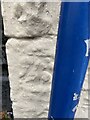
Location of OS Cut Mark - Carmarthen, #7 Lammas Street
Image: © thejackrustles
Taken: 9 Oct 2022
0.01 miles
5
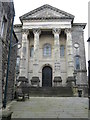
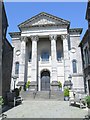
English Baptist Church, Carmarthen
Built in 1869-70, on the site of the Black Horse inn. The work of George Morgan, a leading C19 architect of Carmarthen. It cost £1,800 to build. https://www.britishlistedbuildings.co.uk/300009741-english-baptist-church-carmarthen#.WtISoGeWzGh
Image: © M J Richardson
Taken: 8 Apr 2018
0.01 miles
6
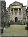
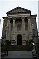
English Baptist Church
The English Baptist Church on Lammas Street. The building has a grand portico and Corinthian columns. The church dates from 1869 and is Grade II* listed.
Image: © Philip Halling
Taken: 16 Jun 2021
0.01 miles
7
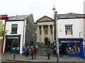
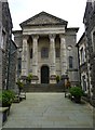
Shops and English Baptist Church, Lammas Street
Looking across the street to Image The iron gateposts, gates and railings are Grade II listed structures and were restored in 2000.
Image: © Rose and Trev Clough
Taken: 14 Oct 2008
0.01 miles
8
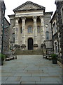
The English Baptist Church in Carmarthen
Built in 1869/70, and occupying the former site of a public house. It holds a Grade II* listing https://www.britishlistedbuildings.co.uk/300009741-english-baptist-church-carmarthen#.WUGXutQrLGg given in 1981, and is described as "one of the most architecturally-ambitious classical chapels in Wales."
Image: © Richard Law
Taken: 30 May 2017
0.01 miles
9
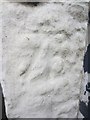
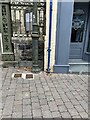
Ordnance Survey Cut Mark
This OS cut mark can be found on No7 Lammas Street. It marks a point 16.480m above mean sea level.
Image: © Adrian Dust
Taken: 25 Jan 2014
0.01 miles
10
OS Cut Mark - Carmarthen, #7 Lammas Street
Image: © thejackrustles
Taken: 9 Oct 2022
0.01 miles