IMAGES TAKEN NEAR TO
Glangwili, CARMARTHEN, SA31 2PN
Introduction
This page details the photographs taken nearby to SA31 2PN by members of the Geograph project.
The Geograph project started in 2005 with the aim of publishing, organising and preserving representative images for every square kilometre of Great Britain, Ireland and the Isle of Man.

There are currently over 7.5m images from over14,400 individuals and you can help contribute to the project by visiting https://www.geograph.org.uk
Image Map (Loading...)


Getting Data...Please wait
Leaflet Map data © OpenStreetMap
Images are licensed for reuse under creativecommons.org/licenses/by-sa/2.0
Notes
- Clicking on the map will re-center to the selected point.
- The higher the marker number, the further away the image location is from the centre of the postcode.
Image Listing (9 Images Found)
Images are licensed for reuse under creativecommons.org/licenses/by-sa/2.0
Image
Details
Distance
1
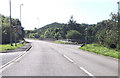
Glangwili bridge from A485
Approaching roundabout for A40
Image: © John Firth
Taken: 5 Sep 2012
0.02 miles
2
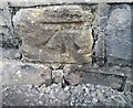
Ordnance Survey Cut Mark
This OS cut mark can be found on the NW parapet of Gwangwili Bridge. It marks a point 14.175m above mean sea level.
Image: © Adrian Dust
Taken: 8 Nov 2019
0.03 miles
4
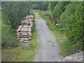
Disused Carmarthen to Aberystwyth railway looking towards Bronwydd Arms
After Abergwili Junction the line from Carmarthen to Aberystwyth continued on towards Bronwydd Arms. The sleepers to the left belong to the Gwili Railway who plan to extend their line from Bronwydd Arms towards Carmarthen.
Image: © Simon Parsons
Taken: 1 Jun 2011
0.09 miles
5
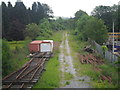
Disused Carmarthen to Aberystwyth railway looking towards Abergwili Junction
After leaving Carmarthen the railway line north split at Abergwili Junction with trains either taking the LNWR line to Llandeilo or the GWR line to Lampeter and Aberystwyth. The site of the junction itself is now under the roundabout on the Carmarthen bypass. The track in the picture belongs to the Gwili Railway who hope to extend their line to this point.
Image: © Simon Parsons
Taken: 1 Jun 2011
0.15 miles
6
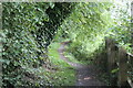
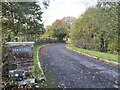
Footpath going north from Dolgwili Road
Public footpath by small stream.
Image: © M J Roscoe
Taken: 25 Aug 2021
0.21 miles
7
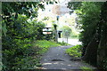
Path to Dolgwili Road, A4243
Combined cycle and pedestrian path by Glangwili Hospital. The metal kissing gate has been bypassed.
Image: © M J Roscoe
Taken: 25 Aug 2021
0.22 miles
8
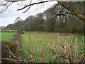
Public footpath
Footpath from Castell Pigyn road to A485
Image: © frank cokayne
Taken: 3 Mar 2012
0.24 miles
9
Ordnance Survey Cut Mark
This OS cut mark can be found below the Letter Box on Bronwydd Road. It marks a point 25.216m above mean sea level.
Image: © Adrian Dust
Taken: 1 Mar 2014
0.25 miles