IMAGES TAKEN NEAR TO
Castell Pigyn Road, CARMARTHEN, SA31 2JH
Introduction
This page details the photographs taken nearby to Castell Pigyn Road, SA31 2JH by members of the Geograph project.
The Geograph project started in 2005 with the aim of publishing, organising and preserving representative images for every square kilometre of Great Britain, Ireland and the Isle of Man.

There are currently over 7.5m images from over14,400 individuals and you can help contribute to the project by visiting https://www.geograph.org.uk
Image Map
Images are licensed for reuse under creativecommons.org/licenses/by-sa/2.0
Notes
- Clicking on the map will re-center to the selected point.
- The higher the marker number, the further away the image location is from the centre of the postcode.
Image Listing (4 Images Found)
Images are licensed for reuse under creativecommons.org/licenses/by-sa/2.0
Image
Details
Distance
1
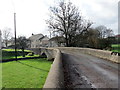
Pont dros Nant Crychiau / Bridge across Crychiau stream
Pont yn rhychwantu Nant Crychiau ger Abergwili.
A bridge spanning the Crychiau (trans. ripples) stream near Abergwili (trans. confluence of the Gwili river).
Image: © Alan Richards
Taken: 14 Nov 2018
0.14 miles
2
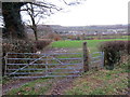
Llwybr ger Cwm / A path near Cwm
Llwybr cyhoeddus yn mynd i gyfeiriad pentre Abergwili.
A public footpath heading in the direction of Abergwili village.
Image: © Alan Richards
Taken: 14 Nov 2018
0.21 miles