IMAGES TAKEN NEAR TO
Gyfre Gardens, CARMARTHEN, SA31 2JD
Introduction
This page details the photographs taken nearby to Gyfre Gardens, SA31 2JD by members of the Geograph project.
The Geograph project started in 2005 with the aim of publishing, organising and preserving representative images for every square kilometre of Great Britain, Ireland and the Isle of Man.

There are currently over 7.5m images from over14,400 individuals and you can help contribute to the project by visiting https://www.geograph.org.uk
Image Map
Images are licensed for reuse under creativecommons.org/licenses/by-sa/2.0
Notes
- Clicking on the map will re-center to the selected point.
- The higher the marker number, the further away the image location is from the centre of the postcode.
Image Listing (69 Images Found)
Images are licensed for reuse under creativecommons.org/licenses/by-sa/2.0
Image
Details
Distance
1
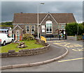
Abergwili school
Located in Gerddi Gyfre (Gyfre Gardens) on the north side of High Street.
Abergwili VC Primary School is a state primary school (for children aged from 3 to 11.)
The VC here signifies a Voluntary Controlled School. Such schools must provide for all pupils to take part in a daily act of collective worship, which must reflect the broad traditions of Christian belief and be wholly Christian in character.
Image: © Jaggery
Taken: 12 Aug 2012
0.01 miles
2
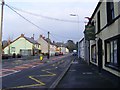
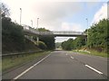
The Wheatsheaf at Abergwili
The Wheatsheaf at Abergwili, near Carmarthen. Image is taken looking along the road through the village. The War Memorial is just to the right of the picture.
Image: © Alan Harris
Taken: 18 Feb 2010
0.05 miles
3
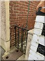
Location of OS Flush Bracket 866 - Abergwili, #16 High Street
Image: © thejackrustles
Taken: 9 Oct 2022
0.06 miles
4
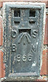
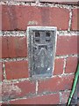
OS Flush Bracket 866 - Abergwili, #16 High Street
https://www.bench-marks.org.uk/bm9993
Image: © thejackrustles
Taken: 23 Oct 2022
0.06 miles
5
Ordnance Survey Flush Bracket (866)
This OS Flush Bracket (866) can be found on the north west angle of No 16 High Street. It was once a post office. It was used during the Second Geodetic Levelling of England & Wales (1912-21) Carmarthen - Llandovery Levelling Line. Also the Third Geodetic Levelling of England & Wales (1950-68) Llandovery - Carmarthen Levelling Line. It marks a point 29.8310ft above mean sea level.
Image: © Adrian Dust
Taken: 2 Jun 2013
0.06 miles
7
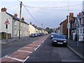
Abergwili
The main street of the village of Abergwili looking eastwards
Image: © Alan Harris
Taken: 18 Feb 2010
0.06 miles
8

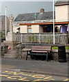
The Wheatsheaf, Abergwili
High Street pub viewed from near the War Memorial. http://www.geograph.org.uk/photo/3080717
Image: © Jaggery
Taken: 12 Aug 2012
0.07 miles
9
War Memorial, Abergwili
The War Memorial in High Street is a granite Celtic cross.
Image: © Jaggery
Taken: 12 Aug 2012
0.07 miles
10
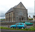
Chapel, Abergwili
The chapel is located on the corner of High Street and Lloyd's Terrace.
The inscription in stone on the wall is CAPEL YR EBENESER ANNIBYNWYR, Welsh for Ebenezer Independent Chapel.
Image: © Jaggery
Taken: 12 Aug 2012
0.08 miles