IMAGES TAKEN NEAR TO
Llangunnor Road, CARMARTHEN, SA31 2HR
Introduction
This page details the photographs taken nearby to Llangunnor Road, SA31 2HR by members of the Geograph project.
The Geograph project started in 2005 with the aim of publishing, organising and preserving representative images for every square kilometre of Great Britain, Ireland and the Isle of Man.

There are currently over 7.5m images from over14,400 individuals and you can help contribute to the project by visiting https://www.geograph.org.uk
Image Map (Loading...)


Getting Data...Please wait
Leaflet Map data © OpenStreetMap
Images are licensed for reuse under creativecommons.org/licenses/by-sa/2.0
Notes
- Clicking on the map will re-center to the selected point.
- The higher the marker number, the further away the image location is from the centre of the postcode.
Image Listing (8 Images Found)
Images are licensed for reuse under creativecommons.org/licenses/by-sa/2.0
Image
Details
Distance
2
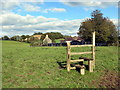
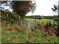
Llwybr Tygwyn / Tygwyn Path
Hen sticil bydredig ddiangen ar lwybr cyhoeddus ger Ffarm Tygwyn.
An old redundant decaying stile on a public footpath near Tygwyn Farm (trans. white house).
Image: © Alan Richards
Taken: 2 Oct 2019
0.06 miles
3
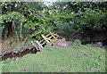
Pompren ddifrodedig / Damaged footbridge
Pompren wedi ei difrodi gan lifogydd.
A footbridge damaged by floods.
Image: © Alan Richards
Taken: 2 Oct 2019
0.10 miles
4
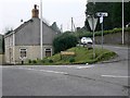
Capel Dewi road
Junction of Capel Dewi and Heol Llangynnwr (B4300) roads.
Image: © frank cokayne
Taken: 1 Mar 2012
0.13 miles
5
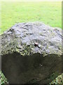
Ordnance Survey Rivet
This OS rivet can be found on the milestone. It marks a point 18.631m above mean sea level. http://www.geograph.org.uk/photo/4331861
Image: © Adrian Dust
Taken: 1 Feb 2015
0.23 miles
6
Milestone - Carmarthen 1
There is an Ordnance Survey rivet on the top of this milestone. http://www.geograph.org.uk/photo/4331858
Image: © Adrian Dust
Taken: 1 Feb 2015
0.23 miles
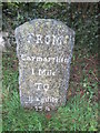
7
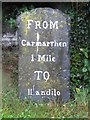
Old Milestone by the B4300, Heol Capel Dewi,
Stone post by the B4300, in parish of Llangunnor (Carmarthenshire District), East of Tygwyn Farm, South side of road, set well back against garden wall.
Inscription reads:-
FROM
Carmarthen
1 Mile
TO
Llandilo
Surveyed
Milestone Society National ID: CAM_CMLO01
Image: © Milestone Society
Taken: Unknown
0.24 miles
8
Llwybr i Eglwys Llangynnwr / Path to Llangunnor Church
Llwybr cyhoeddus yn arwain at Eglwys Llangynnwr.
A public footpath heading towards Llangunnor Church (trans. St Cynyr's church)
Image: © Alan Richards
Taken: 2 Oct 2019
0.25 miles