IMAGES TAKEN NEAR TO
CARMARTHEN, SA31 2ET
Introduction
This page details the photographs taken nearby to SA31 2ET by members of the Geograph project.
The Geograph project started in 2005 with the aim of publishing, organising and preserving representative images for every square kilometre of Great Britain, Ireland and the Isle of Man.

There are currently over 7.5m images from over14,400 individuals and you can help contribute to the project by visiting https://www.geograph.org.uk
Image Map (Loading...)


Getting Data...Please wait
Leaflet Map data © OpenStreetMap
Images are licensed for reuse under creativecommons.org/licenses/by-sa/2.0
Notes
- Clicking on the map will re-center to the selected point.
- The higher the marker number, the further away the image location is from the centre of the postcode.
Image Listing (18 Images Found)
Images are licensed for reuse under creativecommons.org/licenses/by-sa/2.0
Image
Details
Distance
1
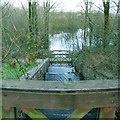
Carmarthen Reservoirs
Looking down from a bridge over the dam of the upper reservoir down the stepped waterfall to the bridge at the back of the lower reservoir.
Image: © Nigel Davies
Taken: 3 Apr 2006
0.09 miles
2
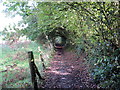
Llwybr i Gronfeydd Cwmoernant / Path to the Cwmoernant Reservoirs
Llwybr cyhoeddus yn arwain at Gronfeydd Cwmoernant.
A public footpath heading towards the Cwmoernant Reservoirs (trans. valley of the cold stream).
Image: © Alan Richards
Taken: 9 Oct 2019
0.14 miles
3
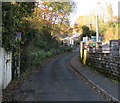
Penlanffos Road, Carmarthen
Penlanffos Road climbs away from the A484, here named Tanerdy, past the edge of Tafarn Tanerdy http://www.geograph.org.uk/photo/3082982 on the right.
Image: © Jaggery
Taken: 12 Aug 2012
0.21 miles
4
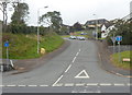
Reservoir Road, Carmarthen
Viewed from the corner of the A484 Tanerdy. Reservoir Road leads to Cwm-oernant Reservoirs.
Image: © Jaggery
Taken: 18 Nov 2019
0.21 miles
5
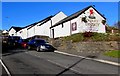
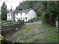
Tafarn Tanerdy, Penlanffos Road, Carmarthen
A Brains Brewery pub viewed from the corner of the A484 Tanerdy.
Image: © Jaggery
Taken: 18 Nov 2019
0.22 miles
6
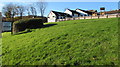
Pub on top of a grassy bank, Carmarthen
The pub is Tafarn Tanerdy. https://www.geograph.org.uk/photo/6326275
Image: © Jaggery
Taken: 18 Nov 2019
0.22 miles
7
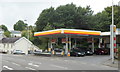
Shell filling station, Tanerdy, Carmarthen
Viewed across Tanerdy (the A484). The filling station is on the corner of Reservoir Road.
Image: © Jaggery
Taken: 12 Aug 2012
0.22 miles
8
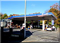
Gulf filling station, Tanerdy, Carmarthen
Set back from the A484 Tanerdy and Reservoir Road viewed in November 2019.
A Shell filling station https://www.geograph.org.uk/photo/3082996 was here in 2012.
Image: © Jaggery
Taken: 18 Nov 2019
0.22 miles
9
Cwm-Oernant
Looking from the start of uphill stretch of public footpath through woods.
Image: © frank cokayne
Taken: 28 Feb 2012
0.22 miles
10
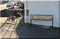
Reservoir Road bilingual name sign, Carmarthen
The sign on the corner of the A484 Tanerdy shows that Reservoir Road https://www.geograph.org.uk/photo/6326304 is Ffordd y Cronlyn in Welsh
Image: © Jaggery
Taken: 18 Nov 2019
0.23 miles