IMAGES TAKEN NEAR TO
The Bridge, CARMARTHEN, SA31 2BN
Introduction
This page details the photographs taken nearby to The Bridge, SA31 2BN by members of the Geograph project.
The Geograph project started in 2005 with the aim of publishing, organising and preserving representative images for every square kilometre of Great Britain, Ireland and the Isle of Man.

There are currently over 7.5m images from over14,400 individuals and you can help contribute to the project by visiting https://www.geograph.org.uk
Image Map
Images are licensed for reuse under creativecommons.org/licenses/by-sa/2.0
Notes
- Clicking on the map will re-center to the selected point.
- The higher the marker number, the further away the image location is from the centre of the postcode.
Image Listing (502 Images Found)
Images are licensed for reuse under creativecommons.org/licenses/by-sa/2.0
Image
Details
Distance
1
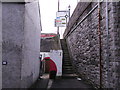
Road sign at top of steps
The road is the A484 at the top of the steps, leading to Pensarn traffic island and the by-pass.
Image: © chris whitehouse
Taken: 4 Feb 2013
0.01 miles
2
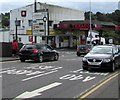
Towy Service Station, Carmarthen
Texaco filling station and small shop alongside the A484, south of Carmarthen Bridge http://www.geograph.org.uk/photo/4617305 over the River Towy.
Image: © Jaggery
Taken: 15 Aug 2015
0.01 miles
3
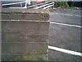
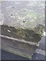
Ordnance Survey Benchmark and Rivet , Carmarthen Bridge
Ordnance Survey Benchmark (OSBM) used for levelling height above Ordnance Datum (OD).
Height: 12.6065m OD (Newlyn). Mark verified by the Ordnance Survey in 1972. Description: RIVET S END WALL E SIDE RD. 1.1m above ground. 3rd Order BM.
Context: Image
Image: © N Scott
Taken: 8 Oct 2013
0.01 miles
4
Ordnance Survey Benchmark and Rivet , Carmarthen Bridge
Ordnance Survey Benchmark (OSBM) used for levelling height above Ordnance Datum (OD).
Height: 12.6065m OD (Newlyn). Mark verified by the Ordnance Survey in 1972. Description: RIVET S END WALL E SIDE RD. 1.1m above ground. 3rd Order BM.
Context: Image
Image: © N Scott
Taken: 8 Oct 2013
0.01 miles
5
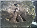
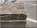
Ordnance Survey Rivet
This OS rivet can be found on the south end of the wall to the east of the road. It marks a point 12.607m above mean sea level.
Image: © Adrian Dust
Taken: 25 Jan 2014
0.01 miles
6
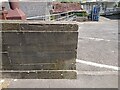
Ordnance Survey Rivet Benchmark - Carmarthen Bridge
Ordnance Survey Benchmark (OSBM) used for levelling height above Ordnance Datum (OD).
Height: 12.6065m OD (Newlyn). Mark verified by the Ordnance Survey in 1972. Description: RIVET S END WALL E SIDE RD. 1.1m above ground. 3rd Order BM.
Context: Image
Image: © N Scott
Taken: 31 May 2023
0.01 miles
7
Ordnance Survey Rivet Benchmark - Carmarthen Bridge
Ordnance Survey Benchmark (OSBM) used for levelling height above Ordnance Datum (OD).
Height: 12.6065m OD (Newlyn). Mark verified by the Ordnance Survey in 1972. Description: RIVET S END WALL E SIDE RD. 1.1m above ground. 3rd Order BM.
Close-up: Image
Image: © N Scott
Taken: 31 May 2023
0.01 miles
8
Old properties
Looking towards Carmarthen Bridge from the east, the properties on the left look more business storage than dwellings, and another blue sign for cycle and pedestrian routes.
Image: © chris whitehouse
Taken: 4 Feb 2013
0.02 miles
9
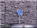
Cycle and pedestrian route sign
To the left is route 47 Tywi, and to the right is route 4 Myrddin.
Image: © chris whitehouse
Taken: 4 Feb 2013
0.02 miles
10
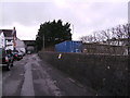
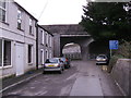
Carmarthen Bridge through the trees
Road with businesses on the left, the Afon Towy is to the right over the stone wall. Name of this road is Old Llangunner Road, Hen Heol Llangynnwr.
Image: © chris whitehouse
Taken: 4 Feb 2013
0.03 miles